IMAGES TAKEN NEAR TO
Clarendon Close, LONDON, W2 2NS
Introduction
This page details the photographs taken nearby to Clarendon Close, W2 2NS by members of the Geograph project.
The Geograph project started in 2005 with the aim of publishing, organising and preserving representative images for every square kilometre of Great Britain, Ireland and the Isle of Man.

There are currently over 7.5m images from over14,400 individuals and you can help contribute to the project by visiting https://www.geograph.org.uk
Image Map
Images are licensed for reuse under creativecommons.org/licenses/by-sa/2.0
Notes
- Clicking on the map will re-center to the selected point.
- The higher the marker number, the further away the image location is from the centre of the postcode.
Image Listing (549 Images Found)
Images are licensed for reuse under creativecommons.org/licenses/by-sa/2.0
Image
Details
Distance
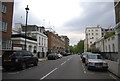
3
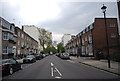
Hyde Park Place, Bayswater Road, London W2
As seen from Bayswater Road.
Image: © Christine Matthews
Taken: 31 Jul 2013
0.05 miles
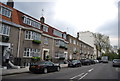
4
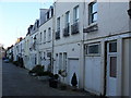
Hyde Park Mews
Quiet backwater in Bayswater where former stables have been converted into desirable town houses.
Image: © Colin Smith
Taken: 20 Dec 2009
0.05 miles
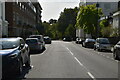
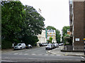
6
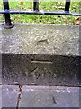
Benchmark on wall of Bayswater Road opposite Hyde Park Street
Ordnance Survey cut mark benchmark described on the Bench Mark Database at http://www.bench-marks.org.uk/bm36485
Image: © Roger Templeman
Taken: 15 Jan 2011
0.05 miles