IMAGES TAKEN NEAR TO
Edgware Road, LONDON, W2 2ER
Introduction
This page details the photographs taken nearby to Edgware Road, W2 2ER by members of the Geograph project.
The Geograph project started in 2005 with the aim of publishing, organising and preserving representative images for every square kilometre of Great Britain, Ireland and the Isle of Man.

There are currently over 7.5m images from over14,400 individuals and you can help contribute to the project by visiting https://www.geograph.org.uk
Image Map
Images are licensed for reuse under creativecommons.org/licenses/by-sa/2.0
Notes
- Clicking on the map will re-center to the selected point.
- The higher the marker number, the further away the image location is from the centre of the postcode.
Image Listing (883 Images Found)
Images are licensed for reuse under creativecommons.org/licenses/by-sa/2.0
Image
Details
Distance
1
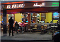
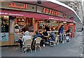
Lebanese restaurant, Edgware Road
Customers sit outside smoking hookahs - water pipes - known in Lebanon as Nargile. The custom is intimately connected to Lebanese hospitality and prevails in all levels of society. The sweet smelling tobacco which wafts into the street is often laced with apple, cinnamon, mint or strawberry. The ill effects of smoking may be reduced but not eliminated and one wonders how the restaurant evades English legal constraints.
Image: © Anthony O'Neil
Taken: 28 Nov 2013
0.00 miles
2
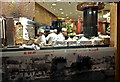
Christmas Chefs
Edgware Road, Marylebone
Image: © Anthony O'Neil
Taken: 25 Dec 2015
0.00 miles
3
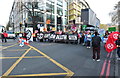
Demo 3
Climate Change protesters block Edgware Road at Marble Arch. Similar groups at Oxford Circus, Tottenham Court Road Station and Parliament Square added to the traffic chaos which caused all central London bus services to be cancelled and made roads impassable for many taxis. Travellers in the affected areas had only two choices: by tube or on foot.
Image: © Anthony O'Neil
Taken: 15 Apr 2019
0.00 miles
4
The Marble Arch Mound
A view of the Marble Arch Mound taken from the A5. The Marble Arch Mound or Marble Arch Hill is a temporary, 25-metre-high artificial hill located next to Marble Arch in London. It has a viewing platform on the summit and an events space inside. The hill opened to the public on 26 July 2021, with a charge, but shortly afterwards it was briefly closed after complaints from the first visitors. It re-opened in August without an entrance fee. It is expected to remain on site until 9 January 2022, after which it will be dismantled.
Image: © Rebecca A Wills
Taken: 22 Sep 2021
0.00 miles
6
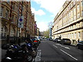
Slow, slow, quick, quick, slower (11)
Seymour Street
Image: © Basher Eyre
Taken: 23 Apr 2016
0.01 miles
7
Eating and Smoking
Middle Eastern style, Seymour Street. (Hookahs do not seem to infringe UK smoking bans.)
Image: © Anthony O'Neil
Taken: 27 Dec 2016
0.01 miles
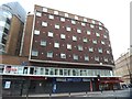
8
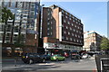
Victory Services Club
Edgware Road - a modern adjunct to Connaught House on Seymour Street.
Image: © Anthony O'Neil
Taken: 21 May 2017
0.01 miles
9
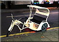
A mixed blessing
Cycle rickshaws may be welcomed by some but, on roads like Oxford Street, being inherently slow and unwieldy, they can create a traffic hazard for buses and cars, and are often at odds with the Met. Police.
Image: © Anthony O'Neil
Taken: 25 Dec 2014
0.01 miles
10
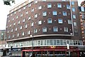
Side elevation of Victory Services Club
The old building (1906) and main entrance is round the corner on Seymour Street.
Image: © Anthony O'Neil
Taken: 15 Oct 2017
0.01 miles