IMAGES TAKEN NEAR TO
Harrow Road, LONDON, W2 1XJ
Introduction
This page details the photographs taken nearby to Harrow Road, W2 1XJ by members of the Geograph project.
The Geograph project started in 2005 with the aim of publishing, organising and preserving representative images for every square kilometre of Great Britain, Ireland and the Isle of Man.

There are currently over 7.5m images from over14,400 individuals and you can help contribute to the project by visiting https://www.geograph.org.uk
Image Map
Images are licensed for reuse under creativecommons.org/licenses/by-sa/2.0
Notes
- Clicking on the map will re-center to the selected point.
- The higher the marker number, the further away the image location is from the centre of the postcode.
Image Listing (544 Images Found)
Images are licensed for reuse under creativecommons.org/licenses/by-sa/2.0
Image
Details
Distance
1
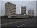
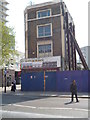
Police Station, Harrow Road
Not just any old police station, this is Paddington Green, the high-security police station in which terrorist suspects are confined in special underground cells. I half expected to be dragged into one of them for having the temerity to photograph the building (I wasn't). One of a cluster of four towers at the east end of Westway, it was built in 1966-71 by J. Innes-Elliot of the Metropolitan Police. There are reliefs at the bottom of the tower, the outline of which is disrupted by the projections which accommodate balconies (presumably for the section house) on the south and north sides.
Image: © Stephen Richards
Taken: 3 Jul 2011
0.01 miles
2
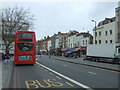
Bus stop on Edgware Road (A5)
Looking north west.
Image: © JThomas
Taken: 18 Mar 2017
0.03 miles
3
Paddington Green Police Station, Harrow Road W2
Image: © Robin Sones
Taken: 4 Feb 2012
0.03 miles
4
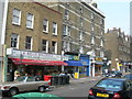
Bell Street, NW1
Showing several shops that cater for the Middle Eastern community near here. The next road on left is Corlett Street, see more of it here Image
Image: © Danny P Robinson
Taken: 29 Apr 2007
0.04 miles
5
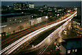
A40 in the rush hour
The A40 on a November evening. In the foreground is the junction with the A5, Edgware Road. On the left is the London Metropole Hotel, beyond which can be seen the new wing of St.Mary's Hospital, whilst Paddington Green Police Station is visible on the right.
Image: © Martin Addison
Taken: Unknown
0.04 miles
6
Propped-up, Edgware Road W2
At the junction with Newcastle Place
Image: © Robin Sones
Taken: 24 May 2012
0.04 miles
8
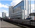
Tower block by Westway, Marylebone
This was (and may still be) occupied by the Civil Service, and I have performed a couple of concerts there for a leaving party.
Image: © David Howard
Taken: 11 Sep 2016
0.04 miles
9
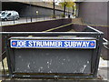
Joe Strummer Subway, Edgware Road
At the junction with Westway
Image: © Robin Sones
Taken: 25 Oct 2012
0.04 miles
10
Deans, Edgware Road W2
At the junction with Newcastle Place
Image: © Robin Sones
Taken: 24 May 2012
0.04 miles