IMAGES TAKEN NEAR TO
Hogan Mews, LONDON, W2 1UP
Introduction
This page details the photographs taken nearby to Hogan Mews, W2 1UP by members of the Geograph project.
The Geograph project started in 2005 with the aim of publishing, organising and preserving representative images for every square kilometre of Great Britain, Ireland and the Isle of Man.

There are currently over 7.5m images from over14,400 individuals and you can help contribute to the project by visiting https://www.geograph.org.uk
Image Map
Images are licensed for reuse under creativecommons.org/licenses/by-sa/2.0
Notes
- Clicking on the map will re-center to the selected point.
- The higher the marker number, the further away the image location is from the centre of the postcode.
Image Listing (911 Images Found)
Images are licensed for reuse under creativecommons.org/licenses/by-sa/2.0
Image
Details
Distance
1
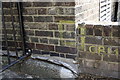
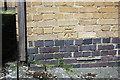
Benchmark on Fleming Court, St Mary's Terrace
Ordnance Survey cut mark benchmark described on the Bench Mark Database at http://www.bench-marks.org.uk/bm23714
Image: © Roger Templeman
Taken: 13 May 2011
0.02 miles
4
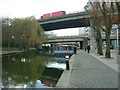
Paddington Basin
The smaller bridge carries Harrow Road, the other bridge in the foreground is the A40 - Westway, elevated section.
Image: © Phillip Perry
Taken: 5 Feb 2007
0.06 miles
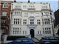
5
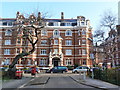
Mansions on St Mary's Terrace, Little Venice, London
Image: © Ruth Sharville
Taken: 11 Feb 2012
0.07 miles
6
Benchmark on John Aird Court, Porteus Road
Ordnance Survey cut mark benchmark described on the Bench Mark Database at http://www.bench-marks.org.uk/bm37916
Image: © Roger Templeman
Taken: 13 May 2011
0.07 miles
7
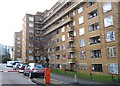
John Aird Court - homes for votes
In the period 1986/1990, Westminster Council had a very narrow Conservative majority and identified Maida Vale as one of eight boroughs where the balance of existing residents were likely to vote Labour in the 1990 local elections.
Under a notorious, secret policy entitled 'Building Stable Communities' the then leader of the Council - Dame Shirley Porter - began to encourage and move local tenants, perceived to be Labour supporters, to the outskirts of London.
Desirable inner London Council properties - like John Aird Court - were then let to Conservative supporters.
After this blatant gerrymandering was detected by other Councils, the District Auditor conducted a detailed investigation and found that Dame Shirley had acted illegally. It was originally estimated that she was personally liable for around £42M in restitution but she had subsequently moved abroad and rearranged her finances within the family: a multi million pound inheritance from the TESCO empire. Following burgeoning legal costs, the Government decided finally to settle for £12M.
To add to the injustice, when Mrs Thatcher's 'Right to buy' policy was implemented, Council tenants renting these desirable apartments found themselves in possession of a potential goldmine, with millionaires living across the street.
Image: © Anthony O'Neil
Taken: 23 Dec 2019
0.07 miles
8
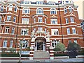
Edwardian comfort
Pre-WWI apartments for the well-to-do of West London.
Image: © Anthony O'Neil
Taken: 23 Dec 2019
0.07 miles
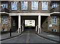
10

Porteus Road Underpass
Providing pedestrian access under Harrow Road. The writing suggests you should use it to get to Little Venice, but personally I'd rather walk along the towpath. Lunchtime office workers pass maintenance men.
Image: © Martin Addison
Taken: 1 Aug 2008
0.08 miles