IMAGES TAKEN NEAR TO
Merchant Square East, LONDON, W2 1AP
Introduction
This page details the photographs taken nearby to Merchant Square East, W2 1AP by members of the Geograph project.
The Geograph project started in 2005 with the aim of publishing, organising and preserving representative images for every square kilometre of Great Britain, Ireland and the Isle of Man.

There are currently over 7.5m images from over14,400 individuals and you can help contribute to the project by visiting https://www.geograph.org.uk
Image Map
Images are licensed for reuse under creativecommons.org/licenses/by-sa/2.0
Notes
- Clicking on the map will re-center to the selected point.
- The higher the marker number, the further away the image location is from the centre of the postcode.
Image Listing (624 Images Found)
Images are licensed for reuse under creativecommons.org/licenses/by-sa/2.0
Image
Details
Distance
1
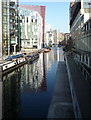
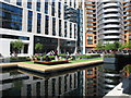
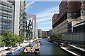
Paddington Basin
I have cropped my original so that this is a very close match to Image And what a change since 2007! The distant view of the Hilton London Metropole hotel has been almost completely obscured by blocks of the new Merchant Square development http://www.merchantsquare.co.uk/. From left to right the buildings are: Waterside House (35 North Wharf Road), 5 Merchant Square (new), 4 Merchant Square (new - with the top of the tower block of the Hilton London Metropole hotel behind it), Balmoral Apartments, part of St Mary's Hospital.
Image: © Roger W Haworth
Taken: 4 Mar 2011
0.01 miles
2
Hilton London Metropole hotel
This is the Praed Street side of the hotel, located on the corner of Edgware Road.
The Hilton London Metropole is one of Europe's largest hotel and conference centres.
There are 1,054 guest bedrooms. Conferences for up to 3,000 delegates can be accommodated.
Image: © Jaggery
Taken: 12 May 2012
0.01 miles
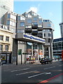
3
Marylebone Flyover, London
The flyover carries the A501 over Edgware Road (the A5). A few tens of metres west of the flyover, the A501 becomes the A40 (Westway). The skyscraper on the right is Burne House. http://www.geograph.org.uk/photo/2946424
Image: © Jaggery
Taken: 12 May 2012
0.01 miles
4
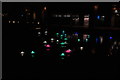
View of Steve Messam's "Flotilla" in the Paddington Basin #9
Looking north-northwest.
Image: © Robert Lamb
Taken: 6 Apr 2018
0.01 miles
5
Floating lawn play area, Paddington Basin
The grass is artificial. The end of Paddington Basin is surrounded by tower blocks, offices and apartments.
Image: © David Hawgood
Taken: 7 May 2018
0.01 miles
6
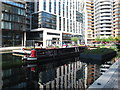
Narrowboat as off-licence bar in Paddington Basin
"Miss Ellie" is moored at the very end of Paddington Basin with a sign "Off licence - open", welcome on a hot bank holiday.
Image: © David Hawgood
Taken: 7 May 2018
0.01 miles
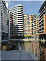
8
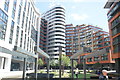
View of blocks of flats in the Paddington Basin from Floating Pocket Park
Looking north-northeast.
Image: © Robert Lamb
Taken: 11 Jun 2017
0.02 miles
9
View of blocks of flats in the Paddington Basin #5
Looking north-northeast.
Image: © Robert Lamb
Taken: 11 Jun 2017
0.02 miles
10
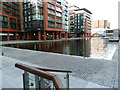
The end of Paddington Basin
A boom prevents navigation to this end of the basin.
Image: © Chris Allen
Taken: 21 May 2015
0.02 miles