IMAGES TAKEN NEAR TO
W1N 1RR
Introduction
This page details the photographs taken nearby to W1N 1RR by members of the Geograph project.
The Geograph project started in 2005 with the aim of publishing, organising and preserving representative images for every square kilometre of Great Britain, Ireland and the Isle of Man.

There are currently over 7.5m images from over14,400 individuals and you can help contribute to the project by visiting https://www.geograph.org.uk
Image Map
Images are licensed for reuse under creativecommons.org/licenses/by-sa/2.0
Notes
- Clicking on the map will re-center to the selected point.
- The higher the marker number, the further away the image location is from the centre of the postcode.
Image Listing (563 Images Found)
Images are licensed for reuse under creativecommons.org/licenses/by-sa/2.0
Image
Details
Distance
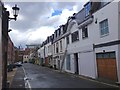
1
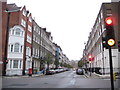
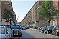
Marylebone: Upper Wimpole Street, W1
Most of this area of Marylebone was built up by about 1793 and became associated with the medical and dental professions, although the reasons for the attraction are not clear. The name Wimpole comes from the location of the country estate in Cambridgeshire owned by the original landlord, Edward Harley, Earl of Oxford, after whom the parallel Harley Street is named. This image was taken looking north up Upper Wimpole Street from its junction with Weymouth Street.
Image: © Nigel Cox
Taken: 3 Dec 2009
0.03 miles
2
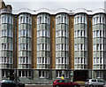
Agnes Keyser House, Beaumont Street
A striking facade with its five full-height bows, their shape echoed by rooftop railings. Built as a nurses' home in the 1950s, part of the King Edward VII's Hospital (Keyser was one of his mistresses). Information partly from here: http://www.flickr.com/photos/ddtmmm/1600795283/
Image: © Stephen Richards
Taken: 29 May 2011
0.03 miles
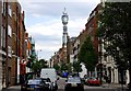
5
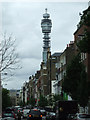
Weymouth Street
Looking towards the BT Tower from Marylebone High Street.
Image: © Thomas Nugent
Taken: 10 Sep 2012
0.04 miles
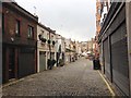
6
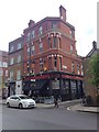
Inn 1888, Marylebone
Formerly the Devonshire Arms.
Image: © Chris Whippet
Taken: 29 Apr 2016
0.06 miles
9
Wimpole Street, Marylebone, from the north
Image: © Dylan Moore
Taken: 14 Jul 2022
0.06 miles
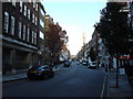
10
Weymouth Street, Marylebone
With a view of the BT Tower (1965).
Image: © Anthony O'Neil
Taken: 11 Apr 2014
0.06 miles