IMAGES TAKEN NEAR TO
Franklin Square, LONDON, W14 9UU
Introduction
This page details the photographs taken nearby to Franklin Square, W14 9UU by members of the Geograph project.
The Geograph project started in 2005 with the aim of publishing, organising and preserving representative images for every square kilometre of Great Britain, Ireland and the Isle of Man.

There are currently over 7.5m images from over14,400 individuals and you can help contribute to the project by visiting https://www.geograph.org.uk
Image Map
Images are licensed for reuse under creativecommons.org/licenses/by-sa/2.0
Notes
- Clicking on the map will re-center to the selected point.
- The higher the marker number, the further away the image location is from the centre of the postcode.
Image Listing (189 Images Found)
Images are licensed for reuse under creativecommons.org/licenses/by-sa/2.0
Image
Details
Distance
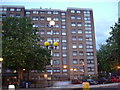
1
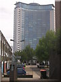
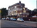
The Empress State Building and Franklin Square W14
Taken from the junction with North End Road W14
Image: © Robin Sones
Taken: 26 Aug 2009
0.00 miles
2
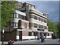
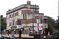
Franklin Square, W14
Although technically a square, only these 2 sides shown are covered with housing.
Image: © Phillip Perry
Taken: 15 Aug 2009
0.02 miles
4
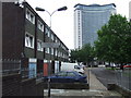
Franklin Square, West Kensington
Franklin Square, a local authority housing development near Earl's Court in West London. In the background is the Empress State Building.
There are currently (in 2011) plans to demolish the estate and redevelop the area.
Image: © Malc McDonald
Taken: 28 Jun 2011
0.03 miles
6
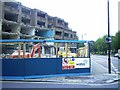
North End Road/Star Road, W14
A council block of flats and a row of shops that weren't even 30 years old being demolished.
Image: © Phillip Perry
Taken: 31 May 2006
0.05 miles
7
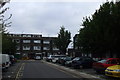
Lickey & Desborough House, W14
2 blocks of flats, part of the West Kensington estate. On the left Lickey House on the right Desborough. North End Road, W14.
Image: © Phillip Perry
Taken: 11 Jun 2008
0.05 miles
8
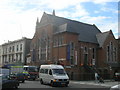
Beds Ltd, North End Road W14
At the junction of Chesson Road W14. The former Methodist New Connexion Church.
Image: © Robin Sones
Taken: 26 Aug 2009
0.06 miles