IMAGES TAKEN NEAR TO
North End Road, LONDON, W14 9UH
Introduction
This page details the photographs taken nearby to North End Road, W14 9UH by members of the Geograph project.
The Geograph project started in 2005 with the aim of publishing, organising and preserving representative images for every square kilometre of Great Britain, Ireland and the Isle of Man.

There are currently over 7.5m images from over14,400 individuals and you can help contribute to the project by visiting https://www.geograph.org.uk
Image Map
Images are licensed for reuse under creativecommons.org/licenses/by-sa/2.0
Notes
- Clicking on the map will re-center to the selected point.
- The higher the marker number, the further away the image location is from the centre of the postcode.
Image Listing (153 Images Found)
Images are licensed for reuse under creativecommons.org/licenses/by-sa/2.0
Image
Details
Distance
1
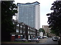
West Kensington Estate and Empress State Building
Local authority housing on the West Kensington Estate in West London. In the background is the Empress State Building.
The local authority has plans (in 2011) to demolish the estate in conjunction with a private developer who would then build new homes on the site.
Image: © Malc McDonald
Taken: 28 Jun 2011
0.02 miles
2
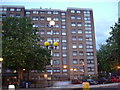
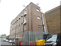
Lickey & Desborough House, W14
2 blocks of flats, part of the West Kensington estate. On the left Lickey House on the right Desborough. North End Road, W14.
Image: © Phillip Perry
Taken: 11 Jun 2008
0.02 miles
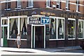

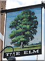
7
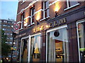
The Elm, North End Road, W14
Taken from a different angle from the previous picture of this pub > http://www.geograph.org.uk/photo/852417.
Image: © Phillip Perry
Taken: 11 Jun 2008
0.03 miles
8
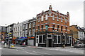
The Elm, North End Road
This is still showing the name of Watney Combe Reid, the makers of the infamous Watney's Red Barrel.
Image: © Bill Boaden
Taken: 29 Jul 2011
0.04 miles
9
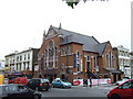
Former church in West Kensington
This building on North End Road in West Kensington was clearly once a church. However it has now been converted into a showroom selling beds.
Image: © Malc McDonald
Taken: 28 Jun 2011
0.04 miles
10
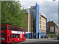
Fulham Telephone Exchange (2)
Taken from North End Road, this photo shows the back of the TE with a jib on the roof above the two entrance doors where the equipment is delivered from outside. This TE used to have FULham telephone numbers until the late 1960s, but now has numbers beginning with 0207, the 0207 referring to the Inner London group of TEs. More recently, lines connected to the former TEs at Earl's Court (TQ2678) and West Kensington (TQ2479) have been transferred to the Fulham TE.
Image: © David Hillas
Taken: 29 Apr 2022
0.04 miles