IMAGES TAKEN NEAR TO
Chesson Road, LONDON, W14 9QT
Introduction
This page details the photographs taken nearby to Chesson Road, W14 9QT by members of the Geograph project.
The Geograph project started in 2005 with the aim of publishing, organising and preserving representative images for every square kilometre of Great Britain, Ireland and the Isle of Man.

There are currently over 7.5m images from over14,400 individuals and you can help contribute to the project by visiting https://www.geograph.org.uk
Image Map
Images are licensed for reuse under creativecommons.org/licenses/by-sa/2.0
Notes
- Clicking on the map will re-center to the selected point.
- The higher the marker number, the further away the image location is from the centre of the postcode.
Image Listing (137 Images Found)
Images are licensed for reuse under creativecommons.org/licenses/by-sa/2.0
Image
Details
Distance
3
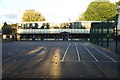
Normand Croft community school, SW6
From when it opened c.1958 until around 2004, it was originally known as Normand Park primary school, it then merged with the Bramber Road nursery (out of shot to the left) to become Normand Croft community school. This building was the 'junior school' with 2 classes per year for 4 years starting with the classrooms in the bottom left-hand corner, finishing top-right. Until merging, the nursery although being on the same site was entirely separate.
The green fence on the right is a playground within a playground.
Apart from the outside toilet block (on the right) been demolished and some cosmetic changes, this place looks unchanged since I left almost 35 years ago.
Image: © Phillip Perry
Taken: 21 Sep 2010
0.07 miles
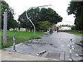
5
Path across Normand Park
It connects Lillie Road with Normand Road.
Image: © Robin Webster
Taken: 13 May 2012
0.09 miles
6
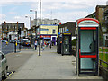
Two telephone boxes, Lillie Road
These are served by two different companies, the far one Spectrum, the nearer BT.
Image: © Robin Webster
Taken: 13 May 2012
0.10 miles
7
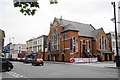
Former Methodist New Connexion church
Now a bed shop.
Image: © Bill Boaden
Taken: 29 Jul 2011
0.10 miles
8
Normand Croft community school II, SW6
From when it opened c.1958 until around 2004, it was originally known as Normand Park primary school, it then merged with the Bramber Road nursery next door to become Normand Croft community school. This building was the 'infant school'. Until merging, the nursery although being on the same site was entirely separate.
Apart from some cosmetic changes, the new building on the right and the shrinking playground, this place looks unchanged since I left this part of the building almost 40 years ago.
Image: © Phillip Perry
Taken: 21 Sep 2010
0.10 miles
9
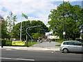
Normand Park, Fulham
An entrance to Normand Park in Fulham, west London.
Image: © Malc McDonald
Taken: 28 Jun 2011
0.10 miles
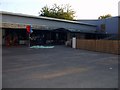
10
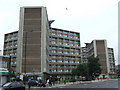
Blocks of flats, Lillie Road, Fulham
Blocks of flats on Lillie Road in Fulham
Image: © Malc McDonald
Taken: 28 Jun 2011
0.10 miles