IMAGES TAKEN NEAR TO
Archel Road, LONDON, W14 9QL
Introduction
This page details the photographs taken nearby to Archel Road, W14 9QL by members of the Geograph project.
The Geograph project started in 2005 with the aim of publishing, organising and preserving representative images for every square kilometre of Great Britain, Ireland and the Isle of Man.

There are currently over 7.5m images from over14,400 individuals and you can help contribute to the project by visiting https://www.geograph.org.uk
Image Map
Images are licensed for reuse under creativecommons.org/licenses/by-sa/2.0
Notes
- Clicking on the map will re-center to the selected point.
- The higher the marker number, the further away the image location is from the centre of the postcode.
Image Listing (136 Images Found)
Images are licensed for reuse under creativecommons.org/licenses/by-sa/2.0
Image
Details
Distance
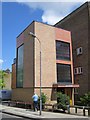
1

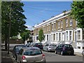
Zenobia Mansions, Queens Club Gardens, W14
One of 33 blocks of flats in this very desirable location of West Kensington, see also pics: Image, Image, Image
Image: © Phillip Perry
Taken: 9 Jun 2004
0.05 miles
3
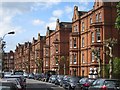
Queen's Club Gardens - Tennyson Mansions
Image: © Phillip Perry
Taken: 26 Jun 2008
0.07 miles
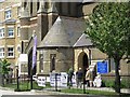
7
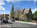
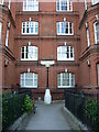
St Andrews Church
Grade II listed church http://list.historicengland.org.uk/resultsingle.aspx?uid=1393119
Image: © Oast House Archive
Taken: 7 May 2015
0.10 miles
9
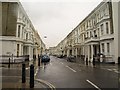
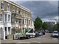
Perham Road, W14
The junction with Vereker Road in the foreground seems to have undergone a recent makeover; satellite imagery at the time of submission shows a mini-roundabout here.
Apologies for the drops of rain on the lens; a steady downpour was taking place.
Image: © Derek Harper
Taken: 6 Jan 2011
0.10 miles
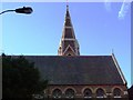
10
Polling Station, St Andrews Church
In the Grade II listed church http://list.historicengland.org.uk/resultsingle.aspx?uid=1393119
Image: © Oast House Archive
Taken: 7 May 2015
0.11 miles