IMAGES TAKEN NEAR TO
Ivatt Place, LONDON, W14 9LW
Introduction
This page details the photographs taken nearby to Ivatt Place, W14 9LW by members of the Geograph project.
The Geograph project started in 2005 with the aim of publishing, organising and preserving representative images for every square kilometre of Great Britain, Ireland and the Isle of Man.

There are currently over 7.5m images from over14,400 individuals and you can help contribute to the project by visiting https://www.geograph.org.uk
Image Map
Images are licensed for reuse under creativecommons.org/licenses/by-sa/2.0
Notes
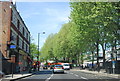
- Clicking on the map will re-center to the selected point.
- The higher the marker number, the further away the image location is from the centre of the postcode.
Image Listing (239 Images Found)
Images are licensed for reuse under creativecommons.org/licenses/by-sa/2.0
Image
Details
Distance
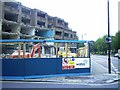
2
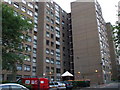
Fairburn House & Churchward House, W14
Two of the blocks of flats on the West Kensington Estate
Image: © Phillip Perry
Taken: 15 Aug 2009
0.04 miles
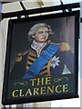
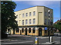
5
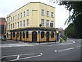
The Clarence public house
In North End Road W14.
Image: © Rod Allday
Taken: 3 Sep 2011
0.05 miles
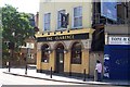
8
Queens Club Wine Stores
North End Road
Image: © Russell Trebor
Taken: 15 Jul 2006
0.05 miles
9
North End Road/Star Road, W14
A council block of flats and a row of shops that weren't even 30 years old being demolished.
Image: © Phillip Perry
Taken: 31 May 2006
0.06 miles
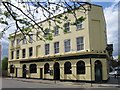
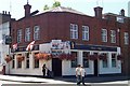
10
The Clarence, North End Road W14
At the junction with May Street W14
Image: © Robin Sones
Taken: 26 Aug 2009
0.06 miles