IMAGES TAKEN NEAR TO
Fairholme Road, LONDON, W14 9JZ
Introduction
This page details the photographs taken nearby to Fairholme Road, W14 9JZ by members of the Geograph project.
The Geograph project started in 2005 with the aim of publishing, organising and preserving representative images for every square kilometre of Great Britain, Ireland and the Isle of Man.

There are currently over 7.5m images from over14,400 individuals and you can help contribute to the project by visiting https://www.geograph.org.uk
Image Map
Images are licensed for reuse under creativecommons.org/licenses/by-sa/2.0
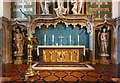
Notes
- Clicking on the map will re-center to the selected point.
- The higher the marker number, the further away the image location is from the centre of the postcode.
Image Listing (192 Images Found)
Images are licensed for reuse under creativecommons.org/licenses/by-sa/2.0
Image
Details
Distance
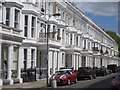
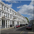
3
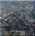
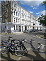
West Kensington from the air
The Queens Club tennis courts are visible in the lower left corner.
Image: © Thomas Nugent
Taken: 31 Jul 2015
0.04 miles
4
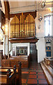
St Andrew, St Andrews Road, West Kensington W14 - Organ
Image: © John Salmon
Taken: 2 Jun 2010
0.04 miles
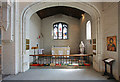
5
St Andrew, St Andrews Road, West Kensington W14 - Sanctuary
Image: © John Salmon
Taken: 2 Jun 2010
0.05 miles
7
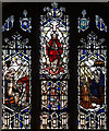
St Andrew, St Andrews Road, West Kensington W14 - Window
Image: © John Salmon
Taken: 2 Jun 2010
0.06 miles
8
St Andrew, St Andrews Road, West Kensington W14 - South chapel
Image: © John Salmon
Taken: 2 Jun 2010
0.06 miles
9
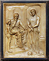
St Andrew, St Andrews Road, West Kensington W14 - Station of the Cross No 1
Image: © John Salmon
Taken: 2 Jun 2010
0.06 miles
10
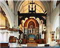
St Andrew, St Andrews Road, West Kensington W14 - Chancel
Image: © John Salmon
Taken: 2 Jun 2010
0.06 miles