IMAGES TAKEN NEAR TO
Comeragh Road, LONDON, W14 9HR
Introduction
This page details the photographs taken nearby to Comeragh Road, W14 9HR by members of the Geograph project.
The Geograph project started in 2005 with the aim of publishing, organising and preserving representative images for every square kilometre of Great Britain, Ireland and the Isle of Man.

There are currently over 7.5m images from over14,400 individuals and you can help contribute to the project by visiting https://www.geograph.org.uk
Image Map
Images are licensed for reuse under creativecommons.org/licenses/by-sa/2.0
Notes
- Clicking on the map will re-center to the selected point.
- The higher the marker number, the further away the image location is from the centre of the postcode.
Image Listing (277 Images Found)
Images are licensed for reuse under creativecommons.org/licenses/by-sa/2.0
Image
Details
Distance
1
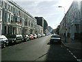
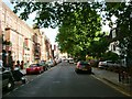
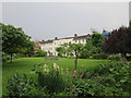
Comeragh Road, W14
Probably every single house pictured here has been split into countless flats or bedsits...........
Image: © Phillip Perry
Taken: 26 Jun 2008
0.02 miles
6
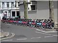
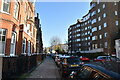
Santander Cycles Docking Station, Vereker Road
Some Barclays branded cycles still remain.
Image: © Oast House Archive
Taken: 7 May 2015
0.06 miles