IMAGES TAKEN NEAR TO
Talgarth Road, LONDON, W14 9DF
Introduction
This page details the photographs taken nearby to Talgarth Road, W14 9DF by members of the Geograph project.
The Geograph project started in 2005 with the aim of publishing, organising and preserving representative images for every square kilometre of Great Britain, Ireland and the Isle of Man.

There are currently over 7.5m images from over14,400 individuals and you can help contribute to the project by visiting https://www.geograph.org.uk
Image Map
Images are licensed for reuse under creativecommons.org/licenses/by-sa/2.0
Notes
- Clicking on the map will re-center to the selected point.
- The higher the marker number, the further away the image location is from the centre of the postcode.
Image Listing (231 Images Found)
Images are licensed for reuse under creativecommons.org/licenses/by-sa/2.0
Image
Details
Distance
1

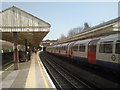
Barons Court station, looking east from the westbound platform
Image: © Christopher Hilton
Taken: 2 Mar 2011
0.01 miles
2

Barons Court station, looking east from the westbound platform
Image: © Christopher Hilton
Taken: 2 Mar 2011
0.01 miles
3
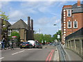
Gliddon Road W14
Looking towards the junction with Talgarth Road W14
Image: © Robin Sones
Taken: 5 May 2009
0.01 miles
4

Railway line Barons Court
The Piccadilly Line heads east from Barons Court station
Image: © David Howard
Taken: 3 Aug 2008
0.02 miles
7

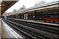
Looking east from Barons Court Underground station
The tracks through Barons Court were first opened on 9 September 1874 when the Metropolitan District Railway opened an extension from Earl's Court to Hammersmith. When the line was constructed, the area now known as Barons Court was open fields and market gardens. By the beginning of the 20th century, the area had been developed for housing and, on 10 October 1905, the District Railway opened the station to serve these new developments and in preparation for the opening of the Great Northern, Piccadilly and Brompton Railway (now the Piccadilly Line), then under construction. The station building is now a Grade II listed building as it retains many of its original features, including terracotta facing and Art Nouveau lettering. Immediately to the east of the station, the Piccadilly Line goes into tunnel and doesn't emerge again until after Bounds Green. The two central tracks seen here are for Piccadilly Line trains.
Image: © Marathon
Taken: 23 Mar 2011
0.03 miles
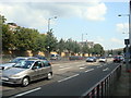
8
Margravine Gardens W14
From the junction with Gliddon Road W14
Image: © Robin Sones
Taken: 5 May 2009
0.03 miles
9
Barons Court Underground station
The tracks through Barons Court were first opened on 9 September 1874 when the Metropolitan District Railway opened an extension from Earl's Court to Hammersmith. When the line was constructed, the area now known as Barons Court was open fields and market gardens. By the beginning of the 20th century, the area had been developed for housing and, on 10 October 1905, the District Railway opened the station to serve these new developments and in preparation for the opening of the Great Northern, Piccadilly and Brompton Railway (now the Piccadilly Line), then under construction. The station building is now a Grade II listed building as it retains many of its original features, including terracotta facing and Art Nouveau lettering. Immediately to the east of the station, the Piccadilly Line goes into tunnel and doesn't emerge again until after Bounds Green. A westbound Piccadilly Line train is seen here.
Image: © Marathon
Taken: 23 Mar 2011
0.03 miles
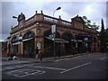
10
Barons Court Station, London
One of the Piccadilly Line stations which is in the open.
Image: © Christine Matthews
Taken: 21 Oct 2012
0.03 miles