IMAGES TAKEN NEAR TO
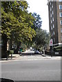
Strangways Terrace, LONDON, W14 8NE
Introduction
This page details the photographs taken nearby to Strangways Terrace, W14 8NE by members of the Geograph project.
The Geograph project started in 2005 with the aim of publishing, organising and preserving representative images for every square kilometre of Great Britain, Ireland and the Isle of Man.

There are currently over 7.5m images from over14,400 individuals and you can help contribute to the project by visiting https://www.geograph.org.uk
Image Map
Images are licensed for reuse under creativecommons.org/licenses/by-sa/2.0
Notes
- Clicking on the map will re-center to the selected point.
- The higher the marker number, the further away the image location is from the centre of the postcode.
Image Listing (367 Images Found)
Images are licensed for reuse under creativecommons.org/licenses/by-sa/2.0
Image
Details
Distance
1
Holland Park Road W14
At the junction with Addison Road
Image: © Robin Sones
Taken: 1 Sep 2010
0.01 miles
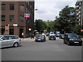
2
Addison Road W14
Looking toward the junction with Kensington High Street
Image: © Robin Sones
Taken: 1 Sep 2010
0.04 miles
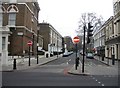
3
A3220 - Addison Road, W14
Part of the Earls Court one-way system
Image: © Phillip Perry
Taken: 25 Jun 2008
0.05 miles
5
Addison Road W14
At the junction of Kensington High Street
Image: © Robin Sones
Taken: 6 Aug 2010
0.05 miles
6
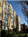
Farley Court , W14
A post-war purpose-built block of flats on Melbury Road.
Image: © Derek Harper
Taken: 19 Mar 2012
0.06 miles
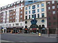
8
Roberson Wine Merchants
Kensington High Street.
Image: © Mr Ignavy
Taken: 15 Jan 2009
0.06 miles
9
Roberson Wine Merchants
Kensington High Street, West London.
Image: © Mr Ignavy
Taken: 15 Jan 2009
0.06 miles
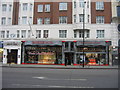
10
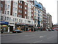
Kensington High Street
Typical large blocks of flats, offices and shops that can be seen all over central London.
Image: © Mr Ignavy
Taken: 15 Jan 2009
0.06 miles