IMAGES TAKEN NEAR TO
Holland Road, LONDON, W14 8BB
Introduction
This page details the photographs taken nearby to Holland Road, W14 8BB by members of the Geograph project.
The Geograph project started in 2005 with the aim of publishing, organising and preserving representative images for every square kilometre of Great Britain, Ireland and the Isle of Man.

There are currently over 7.5m images from over14,400 individuals and you can help contribute to the project by visiting https://www.geograph.org.uk
Image Map
Images are licensed for reuse under creativecommons.org/licenses/by-sa/2.0
Notes
- Clicking on the map will re-center to the selected point.
- The higher the marker number, the further away the image location is from the centre of the postcode.
Image Listing (349 Images Found)
Images are licensed for reuse under creativecommons.org/licenses/by-sa/2.0
Image
Details
Distance
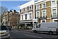
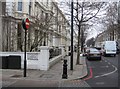
1
Kensington: 68 and 66, Holland Road
See also Image
Image: © Dr Neil Clifton
Taken: 2 Oct 2012
0.02 miles
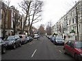
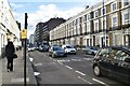
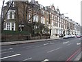
2
Holland Road
Looking northwest from the corner with Fairfax Place.
Image: © Mr Ignavy
Taken: 15 Jan 2009
0.02 miles
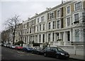
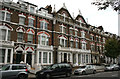
5
Rear view of houses in Holland Road
As seen from Fairfax Place. The houses are opposite the Crown & Sceptre pub.
Image: © Mr Ignavy
Taken: 15 Jan 2009
0.03 miles
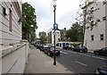
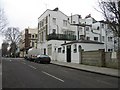
6
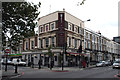
Kensington: The 'Crown and Sceptre', Holland Road
At the corner of Napier Road
Image: © Dr Neil Clifton
Taken: 2 Oct 2012
0.04 miles
7
Holland Road
I guess the red lines help keep the traffic moving so the residents now get more noise?
Image: © Mr Ignavy
Taken: 15 Jan 2009
0.04 miles