IMAGES TAKEN NEAR TO
Masbro Road, LONDON, W14 0LP
Introduction
This page details the photographs taken nearby to Masbro Road, W14 0LP by members of the Geograph project.
The Geograph project started in 2005 with the aim of publishing, organising and preserving representative images for every square kilometre of Great Britain, Ireland and the Isle of Man.

There are currently over 7.5m images from over14,400 individuals and you can help contribute to the project by visiting https://www.geograph.org.uk
Image Map
Images are licensed for reuse under creativecommons.org/licenses/by-sa/2.0
Notes
- Clicking on the map will re-center to the selected point.
- The higher the marker number, the further away the image location is from the centre of the postcode.
Image Listing (205 Images Found)
Images are licensed for reuse under creativecommons.org/licenses/by-sa/2.0
Image
Details
Distance
1
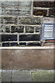
Benchmark on #91 Sinclair Road (Masbro' Road face)
Ordnance Survey cut mark benchmark described on the Bench Mark Database at http://www.bench-marks.org.uk/bm41936
Image: © Roger Templeman
Taken: 10 Mar 2012
0.01 miles
2
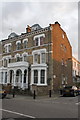
Junction of Masbro' Road and Sinclair Road
There is an OS benchmark Image on the side of the house (#91 Sinclair Road) at the front corner beside the metal air inlet.
Image: © Roger Templeman
Taken: 10 Mar 2012
0.01 miles
3
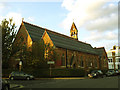
St Matthew's church, Sinclair Road, Kensington
A parish church in the Anglo-Catholic tradition, judging by the mass times given on the notice board. The foundation stone gives a date of 1870.
Image: © Stephen Craven
Taken: 16 Aug 2014
0.02 miles
5
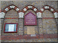
Foundation stone of St Matthew's church
The foundation stone gives a date of 1870. See Image for a photo of the church building as a whole.
Image: © Stephen Craven
Taken: 16 Aug 2014
0.03 miles
6
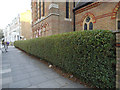
Privet hedge outside St Matthew's church
A very neatly kept hedge on the Sinclair Road frontage. See Image for the church itself.
Image: © Stephen Craven
Taken: 16 Aug 2014
0.03 miles
7
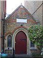
Vestry of St Matthew's church
The stone above the doorway has a rather eroded inscription; the date is now unclear but it was built in memory of Rev. Charles Tucker.
Image: © Stephen Craven
Taken: 16 Aug 2014
0.03 miles
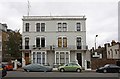
8
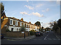
North end of Hofland Road
Typical of the residential streets in this area.
Image: © Stephen Craven
Taken: 16 Aug 2014
0.03 miles
9
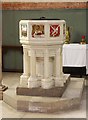
St Matthew, Sinclair Road, London W14 - Font
Image: © John Salmon
Taken: 17 Oct 2009
0.03 miles
10
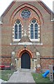
St Matthew, Sinclair Road, London W14 - West door
Image: © John Salmon
Taken: 17 Oct 2009
0.03 miles