IMAGES TAKEN NEAR TO
Addison Gardens, LONDON, W14 0DP
Introduction
This page details the photographs taken nearby to Addison Gardens, W14 0DP by members of the Geograph project.
The Geograph project started in 2005 with the aim of publishing, organising and preserving representative images for every square kilometre of Great Britain, Ireland and the Isle of Man.

There are currently over 7.5m images from over14,400 individuals and you can help contribute to the project by visiting https://www.geograph.org.uk
Image Map
Images are licensed for reuse under creativecommons.org/licenses/by-sa/2.0
Notes
- Clicking on the map will re-center to the selected point.
- The higher the marker number, the further away the image location is from the centre of the postcode.
Image Listing (256 Images Found)
Images are licensed for reuse under creativecommons.org/licenses/by-sa/2.0
Image
Details
Distance
1
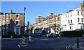
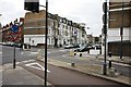
Orange Way after Wiltshire (632)
The walk goes along Addison Gardens and here is a look left (north) on Richmond Way.
Image: © Shazz
Taken: 23 Sep 2013
0.03 miles
2
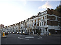
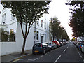
Sinclair Grove
A crescent of houses at the north end of Sinclair Road.
Image: © Stephen Craven
Taken: 16 Aug 2014
0.04 miles
3
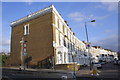
Houses of Sinclair Road
There is an OS benchmark Image on the side of the nearest house at its left hand corner
Image: © Roger Templeman
Taken: 10 Mar 2012
0.06 miles
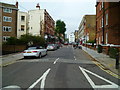
4
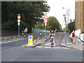
Addison Gardens contraflow
The bridge over the railway is one-way eastbound to motor traffic but there is a contraflow cycle lane, being used here.
Image: © Stephen Craven
Taken: 16 Aug 2014
0.06 miles
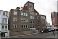
6
Bolingbroke Road
A residential street off Holland Road in West London.
Image: © Stephen Craven
Taken: 16 Aug 2014
0.07 miles
7
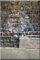
Benchmark on #160 Sinclair Road (Addison Gardens face)
Ordnance Survey cut mark benchmark described on the Bench Mark Database at http://www.bench-marks.org.uk/bm41933
Image: © Roger Templeman
Taken: 10 Mar 2012
0.07 miles
8
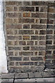
Benchmark on wall pier of Richmond Way
Ordnance Survey cut mark benchmark described on the Bench Mark Database at http://www.bench-marks.org.uk/bm41932
Image: © Roger Templeman
Taken: 10 Mar 2012
0.08 miles
9
'Shepherd's East', Richmond Way
There is an OS benchmark Image on the wall pier next to the white post on the left side of the photo.
Image: © Roger Templeman
Taken: 10 Mar 2012
0.08 miles