IMAGES TAKEN NEAR TO
Netherwood Road, LONDON, W14 0BJ
Introduction
This page details the photographs taken nearby to Netherwood Road, W14 0BJ by members of the Geograph project.
The Geograph project started in 2005 with the aim of publishing, organising and preserving representative images for every square kilometre of Great Britain, Ireland and the Isle of Man.

There are currently over 7.5m images from over14,400 individuals and you can help contribute to the project by visiting https://www.geograph.org.uk
Image Map
Images are licensed for reuse under creativecommons.org/licenses/by-sa/2.0
Notes
- Clicking on the map will re-center to the selected point.
- The higher the marker number, the further away the image location is from the centre of the postcode.
Image Listing (121 Images Found)
Images are licensed for reuse under creativecommons.org/licenses/by-sa/2.0
Image
Details
Distance
1
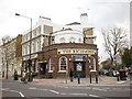
The Richmond, Shepherd Bush Road, Hammersmith
Image: © Alexander P Kapp
Taken: 14 Apr 2009
0.03 miles
2
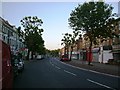
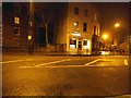
Shepherd's Bush Road, W6
It wouldn't usually be this quiet, it was taken at 5am.
Image: © Phillip Perry
Taken: 26 Jun 2008
0.03 miles
5
Orange Way after Wiltshire (631)
The walk is along Blythe Road for a short distance to the next left turn beyond the one seen in the picture.
Image: © Shazz
Taken: 23 Sep 2013
0.05 miles

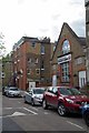
7
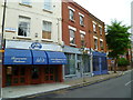
Shops on Shepherds Bush Road
Looking towards Blythe Road
Image: © David Howard
Taken: 6 Jan 2014
0.06 miles
8
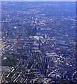
Olympia, Earl's Court and the Thames from the air
Shepherds Bush Central tube station is at the bottom of the photo. The distinctive curved roof at Earl's Court can be clearly seen. Viewed from a Prague bound flight from Heathrow.
Image: © Thomas Nugent
Taken: 10 Apr 2011
0.06 miles
9
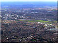
West London and Wembley Stadium from the air
Hammersmith railway station is at the bottom of the photo. Loftus Road football ground and the BBC Television Centre are to the right of the centre, with Wormwood Park and Wembley Stadium beyond.
Image: © Thomas Nugent
Taken: 29 Aug 2011
0.06 miles
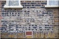
10
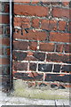
Benchmark on #210 Blyth Road (Marchmont Court)
Ordnance Survey cut mark benchmark described on the Bench Mark Database at http://www.bench-marks.org.uk/bm41934
Image: © Roger Templeman
Taken: 10 Mar 2012
0.07 miles