IMAGES TAKEN NEAR TO
Bolingbroke Road, LONDON, W14 0AA
Introduction
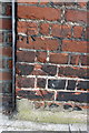
This page details the photographs taken nearby to Bolingbroke Road, W14 0AA by members of the Geograph project.
The Geograph project started in 2005 with the aim of publishing, organising and preserving representative images for every square kilometre of Great Britain, Ireland and the Isle of Man.

There are currently over 7.5m images from over14,400 individuals and you can help contribute to the project by visiting https://www.geograph.org.uk
Image Map
Images are licensed for reuse under creativecommons.org/licenses/by-sa/2.0
Notes
- Clicking on the map will re-center to the selected point.
- The higher the marker number, the further away the image location is from the centre of the postcode.
Image Listing (128 Images Found)
Images are licensed for reuse under creativecommons.org/licenses/by-sa/2.0
Image
Details
Distance
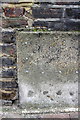
1
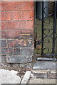
Benchmark on Addison Primary School wall (NE end)
Ordnance Survey cut mark benchmark described on the Bench Mark Database at http://www.bench-marks.org.uk/bm42031
Image: © Roger Templeman
Taken: 10 Mar 2012
0.02 miles
2
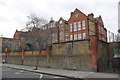
Addison Primary School, Bolingbroke Road
There is an OS benchmark Image on the wall pier at the right hand side of the image next to the metal gate
Image: © Roger Templeman
Taken: 10 Mar 2012
0.02 miles
3
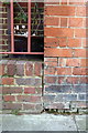
Benchmark on wall pier of Addison Primary School
Ordnance Survey cut mark benchmark described on the Bench Mark Database at http://www.bench-marks.org.uk/bm42030
Image: © Roger Templeman
Taken: 10 Mar 2012
0.03 miles
4
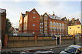
Addison Primary School, Bolingbroke Road
There is an OS benchmark Image on the wall pier at the left hand side of the image
Image: © Roger Templeman
Taken: 10 Mar 2012
0.03 miles
5
Benchmark on #210 Blyth Road (Marchmont Court)
Ordnance Survey cut mark benchmark described on the Bench Mark Database at http://www.bench-marks.org.uk/bm41934
Image: © Roger Templeman
Taken: 10 Mar 2012
0.06 miles
6
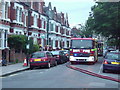
Fire engine in Bolingbroke Road, W14
A fire crew attending a shout in Bolingbroke Road, W14.
Image: © Phillip Perry
Taken: 25 Jun 2008
0.07 miles
7
Junction of Blyth Road and Addison Gardens
There is an OS benchmark Image on the left hand face of the building to the left of the yellow door
Image: © Roger Templeman
Taken: 10 Mar 2012
0.07 miles
8
Benchmark on side of #158 Blyth Road
Ordnance Survey cut mark benchmark described on the Bench Mark Database at http://www.bench-marks.org.uk/bm41935
Image: © Roger Templeman
Taken: 10 Mar 2012
0.08 miles
9

#158 Blyth Road at Berghem Mews entrance
There is an OS benchmark Image on the Bergham Mews face at the rear corner
Image: © Roger Templeman
Taken: 10 Mar 2012
0.09 miles
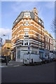
10
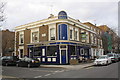
The Havelock Tavern
Pub at junction of Irving Road and Masbro' Road
Image: © Roger Templeman
Taken: 10 Mar 2012
0.11 miles