IMAGES TAKEN NEAR TO
Woodstock Avenue, LONDON, W13 9UF
Introduction
This page details the photographs taken nearby to Woodstock Avenue, W13 9UF by members of the Geograph project.
The Geograph project started in 2005 with the aim of publishing, organising and preserving representative images for every square kilometre of Great Britain, Ireland and the Isle of Man.

There are currently over 7.5m images from over14,400 individuals and you can help contribute to the project by visiting https://www.geograph.org.uk
Image Map
Images are licensed for reuse under creativecommons.org/licenses/by-sa/2.0
Notes
- Clicking on the map will re-center to the selected point.
- The higher the marker number, the further away the image location is from the centre of the postcode.
Image Listing (44 Images Found)
Images are licensed for reuse under creativecommons.org/licenses/by-sa/2.0
Image
Details
Distance
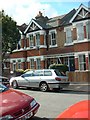
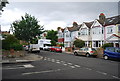
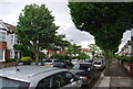
2
Houses in Woodstock Avenue, Ealing
View from Raymond Avenue. The central house has a substantial loft conversion which has altered the front elevation. It is now difficult to get planning permission for loft conversions which change the appearance of the front of the house, but there are many conversions with extra space added at the back of the house.
Image: © David Hawgood
Taken: 4 Jun 2008
0.11 miles
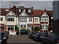
4
Terrace in Mayfield Avenue, Ealing
The appearance of the terrace is substantially changed by the A-shaped projection on the frontage.
Image: © David Hawgood
Taken: 4 Jun 2008
0.12 miles
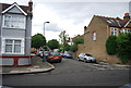
6
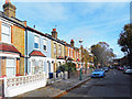
Chamberlain Road, Ealing
Victorian terraces similar to the adjacent streets.
Image: © Des Blenkinsopp
Taken: 9 Nov 2017
0.13 miles
7
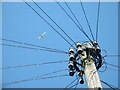
Looking up in Hanwell
Two forms of communication - a telephone line distribution pole [do we still call them 'telegraph' poles?] and an aircraft outward bound from Heathrow. The sky above Hanwell has a constant stream of aircraft, either outward or inward bound [not at the same time].
Image: © David Medcalf
Taken: 19 Jul 2006
0.15 miles
10
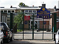
Fielding Primary School, London W13
This is the side entrance to Fielding School, a large primary school that serves the Northfields area. This entrance is on Coombe Road, a short cul-de-sac that has no properties on it.
Image: © Peter Jordan
Taken: 25 Sep 2005
0.16 miles