IMAGES TAKEN NEAR TO
Westfield Road, LONDON, W13 9JP
Introduction
This page details the photographs taken nearby to Westfield Road, W13 9JP by members of the Geograph project.
The Geograph project started in 2005 with the aim of publishing, organising and preserving representative images for every square kilometre of Great Britain, Ireland and the Isle of Man.

There are currently over 7.5m images from over14,400 individuals and you can help contribute to the project by visiting https://www.geograph.org.uk
Image Map
Images are licensed for reuse under creativecommons.org/licenses/by-sa/2.0
Notes
- Clicking on the map will re-center to the selected point.
- The higher the marker number, the further away the image location is from the centre of the postcode.
Image Listing (59 Images Found)
Images are licensed for reuse under creativecommons.org/licenses/by-sa/2.0
Image
Details
Distance
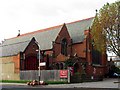
1
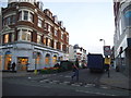
Leeland Road at the junction of Ealing Broadway
The road is used for a market as you can just see
Image: © David Howard
Taken: 28 Nov 2014
0.08 miles
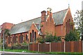
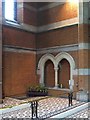
3
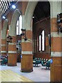
St James, St James Avenue, London W13 - Arcade
Image: © John Salmon
Taken: 3 Nov 2004
0.08 miles
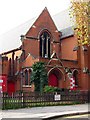
5
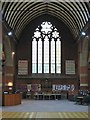
St James, St James Avenue, London W13 - West end
Image: © John Salmon
Taken: 3 Nov 2004
0.09 miles
6
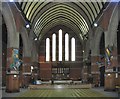
St James, St James Avenue, London W13 - East end
Image: © John Salmon
Taken: 3 Nov 2004
0.09 miles
9
St James, St James Avenue, London W13 - Sedilia
Image: © John Salmon
Taken: 3 Nov 2004
0.09 miles