IMAGES TAKEN NEAR TO
Sydney Road, LONDON, W13 9EY
Introduction
This page details the photographs taken nearby to Sydney Road, W13 9EY by members of the Geograph project.
The Geograph project started in 2005 with the aim of publishing, organising and preserving representative images for every square kilometre of Great Britain, Ireland and the Isle of Man.

There are currently over 7.5m images from over14,400 individuals and you can help contribute to the project by visiting https://www.geograph.org.uk
Image Map
Images are licensed for reuse under creativecommons.org/licenses/by-sa/2.0
Notes
- Clicking on the map will re-center to the selected point.
- The higher the marker number, the further away the image location is from the centre of the postcode.
Image Listing (35 Images Found)
Images are licensed for reuse under creativecommons.org/licenses/by-sa/2.0
Image
Details
Distance
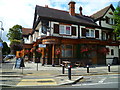
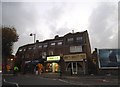
2
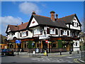
The Forester pub
Since it underwent a major refurbishment in 2012, the pub, at 2 Leighton Road, has become a thriving local.
Image: © Mark Percy
Taken: 23 Apr 2013
0.13 miles
4
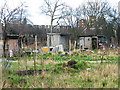
Twitten from Northfield Avenue to Bowmans Close
Image: © Shazz
Taken: 18 Sep 2013
0.13 miles
5
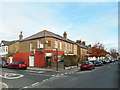
Corner of Burns Road, Ealing, W13
At the junction with Hessel Road.
Image: © Des Blenkinsopp
Taken: 9 Nov 2017
0.13 miles
6
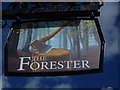
"The Forester" PH on the corner of Seaford Road
Image: © Shazz
Taken: 18 Sep 2013
0.13 miles
7
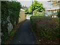
Northfield Avenue looking south towards Leighton Road
Image: © Shazz
Taken: 18 Sep 2013
0.15 miles
10
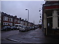
Oaklands Road from the corner of Grosvenor Road
The Grosvenor pub is on the right, something becoming rarer in the 21st century on traditional street corners, one by one they are turning into houses.
Image: © David Howard
Taken: 13 Apr 2013
0.18 miles