IMAGES TAKEN NEAR TO
St. Helens Road, LONDON, W13 9AZ
Introduction
This page details the photographs taken nearby to St. Helens Road, W13 9AZ by members of the Geograph project.
The Geograph project started in 2005 with the aim of publishing, organising and preserving representative images for every square kilometre of Great Britain, Ireland and the Isle of Man.

There are currently over 7.5m images from over14,400 individuals and you can help contribute to the project by visiting https://www.geograph.org.uk
Image Map
Images are licensed for reuse under creativecommons.org/licenses/by-sa/2.0
Notes
- Clicking on the map will re-center to the selected point.
- The higher the marker number, the further away the image location is from the centre of the postcode.
Image Listing (126 Images Found)
Images are licensed for reuse under creativecommons.org/licenses/by-sa/2.0
Image
Details
Distance
1
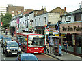
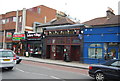
Shops, West Ealing
Apart from a pub at the far end and Age UK, every premises is run for or by the immigrant community, from mostly Asia Minor or Asia, with a small Irish bar. A sign of the past on Rezvan (Finest Persian Cuisine) is the painted wall advertisement for Winsor and Newton's artist's materials.
Image: © Robin Webster
Taken: 6 Oct 2012
0.03 miles
3
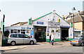
Impact Car Care
Located on Culmington Road. The company provides a range of MOT, servicing and accident repair services for motorists. The Impact company also has a Coach hire arm and a driving school.
Image: © Martin Addison
Taken: 23 Mar 2012
0.04 miles
4
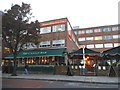
The Castle Bar on Uxbridge Road, Ealing
Image: © David Howard
Taken: 19 Nov 2014
0.04 miles
5

Benchmark on gatepost of Mattock Lane Health Centre
Ordnance Survey cut mark benchmark described on the Bench Mark Database at http://www.bench-marks.org.uk/bm71759
Image: © Roger Templeman
Taken: 16 Nov 2015
0.06 miles
6
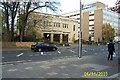
Ealing Fire Station, Uxbridge Road, Ealing W13
This fine municipal building was constructed in 1931.
Image: © Nigel Cox
Taken: 4 Nov 2003
0.06 miles
7
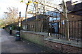
Mattock Lane Health Centre
There is an OS benchmark Image on a gatepost near the far end of the brick wall
Image: © Roger Templeman
Taken: 16 Nov 2015
0.06 miles
9
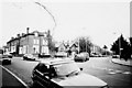
Mattock Lane & Churchfield Road, Ealing
Churchfield Road sweeps off to the right, Mattock Lane off to the left.
Image: © Tom Jolliffe
Taken: Unknown
0.07 miles
10
![Ealing buildings [10]](https://s2.geograph.org.uk/geophotos/06/36/70/6367058_f5af7f73_120x120.jpg)
Ealing buildings [10]
The entrance to Mattock Lane Health Centre.
Ealing is one of the seven major towns in the London Borough of Ealing. A rural village until communications with London got better with the improvements to the road to Oxford (later Uxbridge Road) in the 18th century and culminating with the coming of the railway in 1838. Ealing expanded greatly with suburban development during the 19th century and became known as the "Queen of the Suburbs" due to its greenery and because it was halfway between city and country. Ealing became a municipal borough in 1901. Growth continued throughout the 20th century and Ealing became part of a modern London borough in 1965.
Image: © Michael Dibb
Taken: 14 Sep 2019
0.07 miles