IMAGES TAKEN NEAR TO
Leeland Terrace, LONDON, W13 9AN
Introduction
This page details the photographs taken nearby to Leeland Terrace, W13 9AN by members of the Geograph project.
The Geograph project started in 2005 with the aim of publishing, organising and preserving representative images for every square kilometre of Great Britain, Ireland and the Isle of Man.

There are currently over 7.5m images from over14,400 individuals and you can help contribute to the project by visiting https://www.geograph.org.uk
Image Map
Images are licensed for reuse under creativecommons.org/licenses/by-sa/2.0
Notes
- Clicking on the map will re-center to the selected point.
- The higher the marker number, the further away the image location is from the centre of the postcode.
Image Listing (144 Images Found)
Images are licensed for reuse under creativecommons.org/licenses/by-sa/2.0
Image
Details
Distance
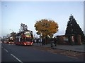
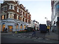
3
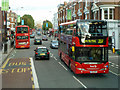
Broadway, West Ealing
A busy bus route.
Image: © Robin Webster
Taken: 6 Oct 2012
0.04 miles
4
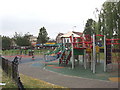
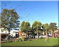
Children's playground in park, West Ealing
South-West of the Broadway/Northfield Avenue junction, this small park is close to the shops and offices and housing of West Ealing
Image: © David Hawgood
Taken: 10 Jun 2005
0.06 miles
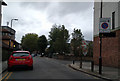
6
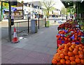
Leeland Road at the junction of Ealing Broadway
The road is used for a market as you can just see
Image: © David Howard
Taken: 28 Nov 2014
0.06 miles
7
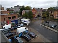
Meat being unloaded from a lorry at the back of Iceland
Image: © Rob Purvis
Taken: 1 Oct 2017
0.07 miles