IMAGES TAKEN NEAR TO
Hastings Road, LONDON, W13 8QH
Introduction
This page details the photographs taken nearby to Hastings Road, W13 8QH by members of the Geograph project.
The Geograph project started in 2005 with the aim of publishing, organising and preserving representative images for every square kilometre of Great Britain, Ireland and the Isle of Man.

There are currently over 7.5m images from over14,400 individuals and you can help contribute to the project by visiting https://www.geograph.org.uk
Image Map
Images are licensed for reuse under creativecommons.org/licenses/by-sa/2.0
Notes
- Clicking on the map will re-center to the selected point.
- The higher the marker number, the further away the image location is from the centre of the postcode.
Image Listing (149 Images Found)
Images are licensed for reuse under creativecommons.org/licenses/by-sa/2.0
Image
Details
Distance
1
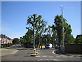
Ealing: Carlton Road, W5 & St Leonards Road, W13
To the right and left respectively, but note the tall sewage system vent pipe, on the pavement to the right, capped with a weather-vane!
Image: © Nigel Cox
Taken: 16 Jul 2006
0.07 miles

3
![Ealing features [2]](https://s1.geograph.org.uk/geophotos/06/36/68/6366829_f58443ed_120x120.jpg)
Ealing features [2]
The lines are seen from the bridge carrying Argyle Road over the railway. The near two lines are for local services and the further two line are part of the Great Western main line.
Ealing is one of the seven major towns in the London Borough of Ealing. A rural village until communications with London got better with the improvements to the road to Oxford (later Uxbridge Road) in the 18th century and culminating with the coming of the railway in 1838. Ealing expanded greatly with suburban development during the 19th century and became known as the "Queen of the Suburbs" due to its greenery and because it was halfway between city and country. Ealing became a municipal borough in 1901. Growth continued throughout the 20th century and Ealing became part of a modern London borough in 1965.
Image: © Michael Dibb
Taken: 14 Sep 2019
0.08 miles
4
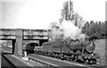
Up GW main line freight near West Ealing
View westward, towards West Ealing, Reading etc. Seen from a Down express, the Class H freight on the Slow line is near Longfield Avenue Box, headed by Collett '2884' class 2-8-0 No. 2892 (built 4/38, withdrawn 5/63).
Image: © Ben Brooksbank
Taken: 13 Apr 1962
0.10 miles
6

Benchmark on St Leonard's Road railway bridge
Ordnance Survey cut mark benchmark described on the Bench Mark Database at http://www.bench-marks.org.uk/bm71762
Image: © Roger Templeman
Taken: 16 Nov 2015
0.11 miles
7
Eastern parapet of railway bridge on St Leonard's Road
There is an OS benchmark Image on the brick pier at the centre of the parapet
Image: © Roger Templeman
Taken: 16 Nov 2015
0.11 miles

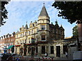
9
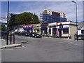
Shops on Drayton Green Road
Single storey shops next to West Ealing station.
Image: © David Howard
Taken: 8 Jul 2008
0.11 miles
10

Benchmark on #15 St Leonard's Road
Ordnance Survey cut mark benchmark described on the Bench Mark Database at http://www.bench-marks.org.uk/bm71761
Image: © Roger Templeman
Taken: 16 Nov 2015
0.12 miles