IMAGES TAKEN NEAR TO
Hollingbourne Gardens, LONDON, W13 8EN
Introduction
This page details the photographs taken nearby to Hollingbourne Gardens, W13 8EN by members of the Geograph project.
The Geograph project started in 2005 with the aim of publishing, organising and preserving representative images for every square kilometre of Great Britain, Ireland and the Isle of Man.

There are currently over 7.5m images from over14,400 individuals and you can help contribute to the project by visiting https://www.geograph.org.uk
Image Map
Images are licensed for reuse under creativecommons.org/licenses/by-sa/2.0
Notes
- Clicking on the map will re-center to the selected point.
- The higher the marker number, the further away the image location is from the centre of the postcode.
Image Listing (68 Images Found)
Images are licensed for reuse under creativecommons.org/licenses/by-sa/2.0
Image
Details
Distance
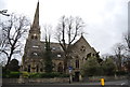
2
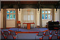
Ealing: St Stephen's Court, The Avenue, W13
This is the former St Stephen's Church at the north end of The Avenue which has been converted into residential use and renamed St Stephen's Court. A two bedroom second floor apartment in the conversion can currently be found for sale at £375,000.
Image: © Nigel Cox
Taken: 8 Sep 2006
0.07 miles
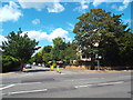
5

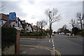
St. Stephen's Avenue, West Ealing
A view eastwards on St. Stephen's Avenue, looking towards St. Stephen's church.
Image: © Malc McDonald
Taken: 2 Jun 2018
0.08 miles
6
![Ealing buildings [4]](https://s0.geograph.org.uk/geophotos/06/36/55/6365568_1ee2dca6_120x120.jpg)
Ealing buildings [4]
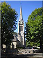
The former church of St Stephen was built in 1876 in the Decorated style and the steeple was added in 1891. The building was deconsecrated in 1979 after subsidence caused it to become unsafe. It was later converted into flats and is now known as St Stephen's Court. The site of the church hall was redeveloped into the current church building. The building is listed, grade II, with details at: https://historicengland.org.uk/listing/the-list/list-entry/1358784
Ealing is one of the seven major towns in the London Borough of Ealing. A rural village until communications with London got better with the improvements to the road to Oxford (later Uxbridge Road) in the 18th century and culminating with the coming of the railway in 1838. Ealing expanded greatly with suburban development during the 19th century and became known as the "Queen of the Suburbs" due to its greenery and because it was halfway between city and country. Ealing became a municipal borough in 1901. Growth continued throughout the 20th century and Ealing became part of a modern London borough in 1965.
Image: © Michael Dibb
Taken: 14 Sep 2019
0.09 miles
8
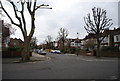
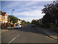
Kent Avenue, near Ealing
Kent Avenue, near Ealing in the suburbs of West London
Image: © Malc McDonald
Taken: 2 Jun 2018
0.09 miles
9
Church of St Stephen
Grade II listed. http://www.britishlistedbuildings.co.uk/en-201033-church-of-st-stephen-ealing
Image: © N Chadwick
Taken: 18 Mar 2012
0.09 miles
10
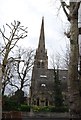
Church of St Stephen
Grade II listed. http://www.britishlistedbuildings.co.uk/en-201033-church-of-st-stephen-ealing
Image: © N Chadwick
Taken: 18 Mar 2012
0.09 miles