IMAGES TAKEN NEAR TO
Argyle Road, LONDON, W13 8AB
Introduction
This page details the photographs taken nearby to Argyle Road, W13 8AB by members of the Geograph project.
The Geograph project started in 2005 with the aim of publishing, organising and preserving representative images for every square kilometre of Great Britain, Ireland and the Isle of Man.

There are currently over 7.5m images from over14,400 individuals and you can help contribute to the project by visiting https://www.geograph.org.uk
Image Map
Images are licensed for reuse under creativecommons.org/licenses/by-sa/2.0
Notes
- Clicking on the map will re-center to the selected point.
- The higher the marker number, the further away the image location is from the centre of the postcode.
Image Listing (127 Images Found)
Images are licensed for reuse under creativecommons.org/licenses/by-sa/2.0
Image
Details
Distance
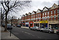
2
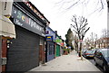
Argyle Road, West Ealing
Argyle Road in West Ealing, in the suburbs of West London.
Image: © Malc McDonald
Taken: 2 Jun 2018
0.03 miles
3
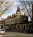
Drayton Court Hotel, West Ealing
Ostentatious High Victoriana dominating the suburb of West Ealing (or Ealing Dean). According to this http://en.wikipedia.org/wiki/The_Drayton_Court , the buildings dates from 1894.
Image: © Jim Osley
Taken: 6 Feb 2015
0.03 miles
6
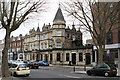
The Drayton Court Hotel
Located on The Avenue, close to West Ealing station.
Image: © Martin Addison
Taken: 13 Feb 2013
0.04 miles
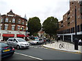
7
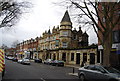
![Ealing buildings [5]](https://s0.geograph.org.uk/geophotos/06/36/55/6365592_e280d141_120x120.jpg)
Ealing buildings [5]
The Drayton Court Hotel was opened in 1894. A hotel until the 1940s when it became just a public house. Refurbished in 2011 it is once again a 4 star hotel. The former Vietnamese revolutionary and statesman, Hồ Chí Minh, worked in the hotel kitchens in 1914.
Ealing is one of the seven major towns in the London Borough of Ealing. A rural village until communications with London got better with the improvements to the road to Oxford (later Uxbridge Road) in the 18th century and culminating with the coming of the railway in 1838. Ealing expanded greatly with suburban development during the 19th century and became known as the "Queen of the Suburbs" due to its greenery and because it was halfway between city and country. Ealing became a municipal borough in 1901. Growth continued throughout the 20th century and Ealing became part of a modern London borough in 1965.
Image: © Michael Dibb
Taken: 14 Sep 2019
0.04 miles
9
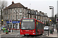
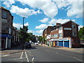
Argyle Road, West Ealing
A bus on the E7 route to Ealing Broadway from Ruislip begins the short sharp climb up to the bridge at West Ealing Station. Argyle corner in the background is probably an unofficial name - it is the junction of Argyle Road and Manor Road.
Image: © Martin Addison
Taken: 13 Feb 2013
0.04 miles
