IMAGES TAKEN NEAR TO
Argyle Road, LONDON, W13 0LY
Introduction
This page details the photographs taken nearby to Argyle Road, W13 0LY by members of the Geograph project.
The Geograph project started in 2005 with the aim of publishing, organising and preserving representative images for every square kilometre of Great Britain, Ireland and the Isle of Man.

There are currently over 7.5m images from over14,400 individuals and you can help contribute to the project by visiting https://www.geograph.org.uk
Image Map
Images are licensed for reuse under creativecommons.org/licenses/by-sa/2.0
Notes
- Clicking on the map will re-center to the selected point.
- The higher the marker number, the further away the image location is from the centre of the postcode.
Image Listing (69 Images Found)
Images are licensed for reuse under creativecommons.org/licenses/by-sa/2.0
Image
Details
Distance
1
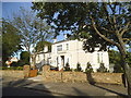
The Congregation of Marian Fathers Divine Mercy Apostolate
2 Courtfield Gardens, West Ealing
Image: © David Howard
Taken: 4 Jul 2015
0.03 miles
2
Unusual building on Sutherland Road, West Ealing
I originally thought this was a house but clearly no front door and shutters where the windows would be.
Image: © David Howard
Taken: 8 Jul 2008
0.07 miles
3
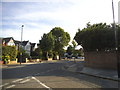
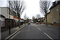
Highview Road at the junction of Courtfield Gardens
Image: © David Howard
Taken: 4 Jul 2015
0.09 miles

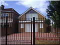
8
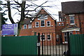
The chapel of the International Presbyterian Church
Grade II listed, formerly, until 1979, the chapel of St. Helena's Convent.
Image: © Graham Weeks
Taken: 9 Apr 2004
0.14 miles
9
![Ealing houses [4]](https://s1.geograph.org.uk/geophotos/06/36/55/6365585_e6b75cf9_120x120.jpg)
Ealing houses [4]
This block of 5 townhouses all have 83 The Avenue as their address. They have recently been built on the site of Ealing College Upper School. Nigel Chadwick photographed the college in 2012 from almost exactly the same spot as the current image - see Image
Ealing is one of the seven major towns in the London Borough of Ealing. A rural village until communications with London got better with the improvements to the road to Oxford (later Uxbridge Road) in the 18th century and culminating with the coming of the railway in 1838. Ealing expanded greatly with suburban development during the 19th century and became known as the "Queen of the Suburbs" due to its greenery and because it was halfway between city and country. Ealing became a municipal borough in 1901. Growth continued throughout the 20th century and Ealing became part of a modern London borough in 1965.
Image: © Michael Dibb
Taken: 14 Sep 2019
0.14 miles
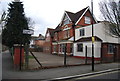
10
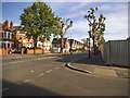
The Avenue at the junction of College Road
Image: © David Howard
Taken: 4 Jul 2015
0.14 miles