IMAGES TAKEN NEAR TO
Drayton Gardens, LONDON, W13 0LG
Introduction
This page details the photographs taken nearby to Drayton Gardens, W13 0LG by members of the Geograph project.
The Geograph project started in 2005 with the aim of publishing, organising and preserving representative images for every square kilometre of Great Britain, Ireland and the Isle of Man.

There are currently over 7.5m images from over14,400 individuals and you can help contribute to the project by visiting https://www.geograph.org.uk
Image Map
Images are licensed for reuse under creativecommons.org/licenses/by-sa/2.0
Notes
- Clicking on the map will re-center to the selected point.
- The higher the marker number, the further away the image location is from the centre of the postcode.
Image Listing (136 Images Found)
Images are licensed for reuse under creativecommons.org/licenses/by-sa/2.0
Image
Details
Distance
1
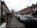
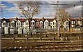
Drayton Avenue, West Ealing, London W13
Looking west along Drayton Avenue. The eastern end of the street has a variety of housing, but most of the street has very homogenous houses, built in very long terraces.
Image: © Peter Jordan
Taken: 18 Mar 2006
0.02 miles
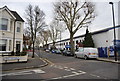
2
Houses on Manor Road, West Ealing, from the train
Image: © Christopher Hilton
Taken: 22 Jun 2013
0.07 miles
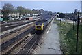
7
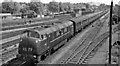
Diesel-hauled Down express near West Ealing
View eastward, towards Paddington; GWR main line to Reading and the West. NB Loco/MAN Type 4 2,200 hp Diesel-Hydraulic B-B No. D836 'Powerful' heads the 11.45 Paddington - Bristol. The lines going off on the left from West Ealing Junction Box are the beginning of the Greenford Loop. Behind the Box is the Milk Dock.
Image: © Ben Brooksbank
Taken: 8 Jun 1962
0.09 miles
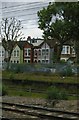
8
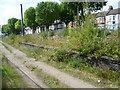
The disused milk train platforms at West Ealing
The station was opened in 1871 as "Castle Hill and Ealing Dene" by the Great Western Railway, which had opened its broad gauge tracks between Paddington and Taplow on 4th June 1838. The last broad-gauge services were operated in 1892.
The station was located next to the London Co-operative Societies main creamery, and so was equipped with a dedicated milk train platform. The milk depot was closed long ago but the derelict platforms still remained in 2014. They are seen here from platform 4 which is the up stopping platform. The houses of Manor Road can be seen behind. However, as part of the Crossrail proposal, services from the Greenford Branch Line will terminate at West Ealing and this will be enabled by converting the former LCS milk train bay into an extra bay platform.
Image: © Marathon
Taken: 3 Sep 2014
0.09 miles
9
Heading West from Paddington
The 1330 Paddington to Penzance service passes West Ealing at speed. On the right now stands the Waitrose supermarket. The Railway has been electrified and overhead wires would prevent the same view today. The footbridge has been enclosed with wire mesh so you could not lean over and photograph the same view as I did then. The track work has also changed as have the trains running into Paddington these days.
Image: © roger geach
Taken: Unknown
0.09 miles
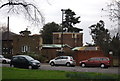
10
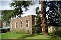
The chapel of the International Presbyterian Church
Grade II listed, formerly, until 1979, the chapel of St. Helena's Convent.
Image: © Graham Weeks
Taken: 9 Apr 2004
0.10 miles