IMAGES TAKEN NEAR TO
Williams Road, LONDON, W13 0FQ
Introduction
This page details the photographs taken nearby to Williams Road, W13 0FQ by members of the Geograph project.
The Geograph project started in 2005 with the aim of publishing, organising and preserving representative images for every square kilometre of Great Britain, Ireland and the Isle of Man.

There are currently over 7.5m images from over14,400 individuals and you can help contribute to the project by visiting https://www.geograph.org.uk
Image Map (Loading...)


Getting Data...Please wait
Leaflet Map data © OpenStreetMap
Images are licensed for reuse under creativecommons.org/licenses/by-sa/2.0
Notes
- Clicking on the map will re-center to the selected point.
- The higher the marker number, the further away the image location is from the centre of the postcode.
Image Listing (114 Images Found)
Images are licensed for reuse under creativecommons.org/licenses/by-sa/2.0
Image
Details
Distance
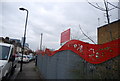
1
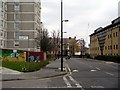
Singapore Road, West Ealing, London W13
Looking east along Singapore Road towards Ealing Magistrates Court at the end. Singapore Road runs parallel to West Ealing Broadwayand is the southern boundary of the Green Man Estate, into which leads Williams Road.
Image: © Peter Jordan
Taken: 18 Mar 2006
0.05 miles
2
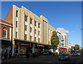
Poundworld, Broadway, West Ealing
This fine deco facade was formerly Woolworths, which along with several other big name stores has given up the struggle.
Image: © Des Blenkinsopp
Taken: 27 Oct 2014
0.07 miles
3
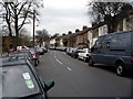
Felix Road, West Ealing, London W13
Looking west along Felix Road. The small terrace houses on the right back onto the Great Western mainline. It's hard to find a parking space round here.
Image: © Peter Jordan
Taken: 18 Mar 2006
0.08 miles
4
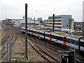
Great Western mainline, West Ealing
A busy scene, looking east. On the left the Greenford branch merges with the Great Western Mainline. On the slow down mainline a Heathrow Connect service heads for the airport, after calling at West Ealing station (just visible). This is the new stopping service to Heathrow. Waitrose have built a new store on the car park of its old store. The new store car park and an office or apartment block have been built on the site of an industrial estate.
Image: © Peter Jordan
Taken: 18 Mar 2006
0.08 miles
6
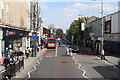
The Broadway, West Ealing
The A4020 seen from the top deck of an 83 bus.
Image: © Martin Addison
Taken: 6 Apr 2012
0.09 miles

8
Felix Road, Romsey Road and the Green Man Estate, London W13
Looking south from the footbridge over the Great Western mainline. The road running left to right is Felix Road. Across Felix Road, Romsey Road leads into the Green Man Estate.
Image: © Peter Jordan
Taken: 18 Mar 2006
0.10 miles
9

West Ealing: Manor Road footbridge
This footbridge crosses the Great Western main line railway and the Greenford branch railway, from Felix Road to the south to Manor Road and Drayton Green to the North.
Image: © Nigel Cox
Taken: 16 Jul 2006
0.10 miles
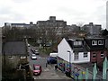
10

Access Self Storage, West Ealing
The grey storage containers behind the trackside fence are between the main Paddington railway line and the branch to Drayton Green and Greenford. The Access Self Storage building itself, on the right, is beyond the branch line (as shown in Image), on Manor Road. Behind it can be seen staggered semi-detached houses on Drayton Green; the trees opposite the houses run along the edge of the park at Drayton Green.
Image: © Derek Harper
Taken: 19 Mar 2012
0.10 miles