IMAGES TAKEN NEAR TO
Kingsley Avenue, LONDON, W13 0EE
Introduction
This page details the photographs taken nearby to Kingsley Avenue, W13 0EE by members of the Geograph project.
The Geograph project started in 2005 with the aim of publishing, organising and preserving representative images for every square kilometre of Great Britain, Ireland and the Isle of Man.

There are currently over 7.5m images from over14,400 individuals and you can help contribute to the project by visiting https://www.geograph.org.uk
Image Map
Images are licensed for reuse under creativecommons.org/licenses/by-sa/2.0
Notes
- Clicking on the map will re-center to the selected point.
- The higher the marker number, the further away the image location is from the centre of the postcode.
Image Listing (36 Images Found)
Images are licensed for reuse under creativecommons.org/licenses/by-sa/2.0
Image
Details
Distance
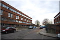
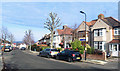
2
Highview Road at the junction of Claremont Road
Image: © David Howard
Taken: 4 Jul 2015
0.13 miles
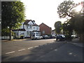
3
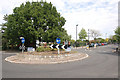
Junction of Argyle Road and Cleveland Road, West Ealing, W13 (4)
Image: © MrC
Taken: 10 May 2009
0.15 miles
4
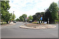
Junction of Argyle Road and Cleveland Road, West Ealing, W13 (3)
Disused public conveniences can just be discerned behind the tree. See also Image
Image: © MrC
Taken: 10 May 2009
0.15 miles
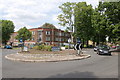
5
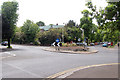
Junction of Argyle Road and Cleveland Road, West Ealing, W13 (2)
Image: © MrC
Taken: 10 May 2009
0.15 miles
6
Junction of Argyle Road and Cleveland Road, West Ealing, W13 (1)
Image: © MrC
Taken: 10 May 2009
0.15 miles
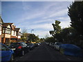
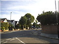
8
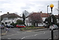
Cleveland Road, Ealing
Typical road for this area.
Image: © Des Blenkinsopp
Taken: 20 Jan 2020
0.16 miles
9
Highview Road at the junction of Courtfield Gardens
Image: © David Howard
Taken: 4 Jul 2015
0.17 miles