IMAGES TAKEN NEAR TO
Argyle Road, LONDON, W13 0DB
Introduction
This page details the photographs taken nearby to Argyle Road, W13 0DB by members of the Geograph project.
The Geograph project started in 2005 with the aim of publishing, organising and preserving representative images for every square kilometre of Great Britain, Ireland and the Isle of Man.

There are currently over 7.5m images from over14,400 individuals and you can help contribute to the project by visiting https://www.geograph.org.uk
Image Map
Images are licensed for reuse under creativecommons.org/licenses/by-sa/2.0
Notes
- Clicking on the map will re-center to the selected point.
- The higher the marker number, the further away the image location is from the centre of the postcode.
Image Listing (63 Images Found)
Images are licensed for reuse under creativecommons.org/licenses/by-sa/2.0
Image
Details
Distance
2
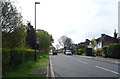
Argyle Road (B452), West Ealing, London
Looking south.
Image: © JThomas
Taken: 13 Apr 2019
0.03 miles
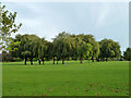
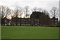
3
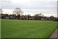
Cleveland Park
Cleveland Park is on the south side of Scotch Common.
Image: © Marathon
Taken: 3 Sep 2014
0.04 miles
4
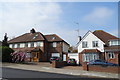
Houses on Argyle Road (B452), West Ealing, London
Image: © JThomas
Taken: 13 Apr 2019
0.05 miles
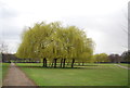
5
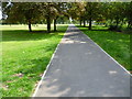
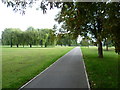
Path in Cleveland Park
Cleveland Park is on the south side of Scotch Common.
Image: © Marathon
Taken: 3 Sep 2014
0.05 miles
8
Roundabout on Scotch Common (B455), West Ealing
Image: © JThomas
Taken: 13 Apr 2019
0.07 miles
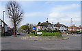
10
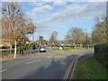
Roundabout on the junction of Argyle Road and Scotch Common
Image: © Rod Allday
Taken: 13 Nov 2019
0.08 miles