IMAGES TAKEN NEAR TO
Gurnell Grove, LONDON, W13 0AQ
Introduction
This page details the photographs taken nearby to Gurnell Grove, W13 0AQ by members of the Geograph project.
The Geograph project started in 2005 with the aim of publishing, organising and preserving representative images for every square kilometre of Great Britain, Ireland and the Isle of Man.

There are currently over 7.5m images from over14,400 individuals and you can help contribute to the project by visiting https://www.geograph.org.uk
Image Map
Images are licensed for reuse under creativecommons.org/licenses/by-sa/2.0
Notes
- Clicking on the map will re-center to the selected point.
- The higher the marker number, the further away the image location is from the centre of the postcode.
Image Listing (53 Images Found)
Images are licensed for reuse under creativecommons.org/licenses/by-sa/2.0
Image
Details
Distance
1
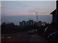
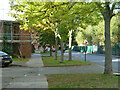
Cuckoo Estate, Ruislip Road East
3 of the tower blocks of the Cuckoo Estate.
Image: © Phillip Perry
Taken: 2 Nov 2008
0.09 miles
5
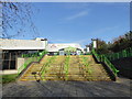
Steps at the entrance to Gurnell Leisure Centre
Image: © Rod Allday
Taken: 13 Nov 2019
0.13 miles
7
Copley Close, Ealing
Parallel with the railway on the right.
Image: © Robin Webster
Taken: 13 Oct 2012
0.13 miles
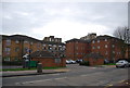
8
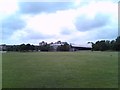
View of the Gurnell Sports Centre from the meadow behind it
Looking south-southeast. The three tower blocks beyond are all on Gurnell Grove and are called Kestrel, Dunlin and Falcon Houses.
Image: © Robert Lamb
Taken: 5 Jun 2012
0.13 miles