IMAGES TAKEN NEAR TO
Gurnell Grove, LONDON, W13 0AG
Introduction
This page details the photographs taken nearby to Gurnell Grove, W13 0AG by members of the Geograph project.
The Geograph project started in 2005 with the aim of publishing, organising and preserving representative images for every square kilometre of Great Britain, Ireland and the Isle of Man.

There are currently over 7.5m images from over14,400 individuals and you can help contribute to the project by visiting https://www.geograph.org.uk
Image Map
Images are licensed for reuse under creativecommons.org/licenses/by-sa/2.0
Notes
- Clicking on the map will re-center to the selected point.
- The higher the marker number, the further away the image location is from the centre of the postcode.
Image Listing (47 Images Found)
Images are licensed for reuse under creativecommons.org/licenses/by-sa/2.0
Image
Details
Distance
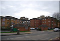
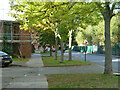
2
Cuckoo Estate, Ruislip Road East
3 of the tower blocks of the Cuckoo Estate.
Image: © Phillip Perry
Taken: 2 Nov 2008
0.06 miles
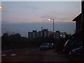
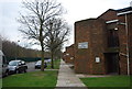
5
Copley Close, Ealing
Parallel with the railway on the right.
Image: © Robin Webster
Taken: 13 Oct 2012
0.10 miles
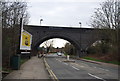
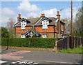
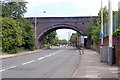
8
Railway bridge over Ruislip Road East (B455)
Looking west.
Image: © JThomas
Taken: 13 Apr 2019
0.11 miles
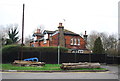
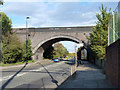
9
Railway bridge over Ruislip Road East, Hanwell, W7
Image: © MrC
Taken: 10 May 2009
0.11 miles
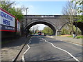
10
Railway over Ruislip Road East
The Greenford branch crosses with a single large span brick arch, part of a short viaduct also crossing the River Brent to the left.
Image: © Robin Webster
Taken: 13 Oct 2012
0.11 miles