IMAGES TAKEN NEAR TO
Emlyn Road, LONDON, W12 9TB
Introduction
This page details the photographs taken nearby to Emlyn Road, W12 9TB by members of the Geograph project.
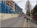
The Geograph project started in 2005 with the aim of publishing, organising and preserving representative images for every square kilometre of Great Britain, Ireland and the Isle of Man.

There are currently over 7.5m images from over14,400 individuals and you can help contribute to the project by visiting https://www.geograph.org.uk
Image Map
Images are licensed for reuse under creativecommons.org/licenses/by-sa/2.0
Notes
- Clicking on the map will re-center to the selected point.
- The higher the marker number, the further away the image location is from the centre of the postcode.
Image Listing (56 Images Found)
Images are licensed for reuse under creativecommons.org/licenses/by-sa/2.0
Image
Details
Distance
1
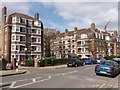
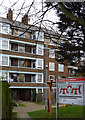
Emlyn Gardens flats, Bedford Park
A large estate of similar blocks of flats.
Image: © David Hawgood
Taken: 25 Mar 2008
0.03 miles
2
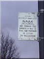
Council sign for dog fouling, Cobbold Road, Acton
Hammersmith Council have issued many of these signs, which would be no newer than the 1960s based on the construction and fonts. There are also enamel versions as well as pressed alloy like these.
Image: © David Howard
Taken: 14 Feb 2010
0.03 miles
3
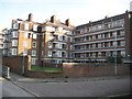
Hammersmith: Emlyn Gardens, W12
The Emlyn Gardens flats were built about 1930. In this view from Warple Way, 2 of the 14 blocks are visible with Longford Court to the left and Lea Court to the right.
Image: © Nigel Cox
Taken: 25 Sep 2011
0.06 miles
4
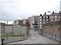
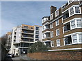
The bottom of Warple Way
Emlyn Gardens flats to the right with the Factory Quarter (former C.A.V. site) development behind.
Image: © Alan Murray-Rust
Taken: 10 Jan 2012
0.06 miles
5
Mace Montessori Nursery School, North Chiswick
Small school within Edison Court, part of the Factory Quarter residential development, on the site of a former C.A.V. electrical components factory.
Image: © David Anstiss
Taken: 14 Apr 2013
0.06 miles
6
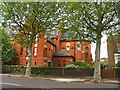
St Mary's in Stamford Brook Road
This church is situated on the A402 in the south eastern corner of the grid square.
Image: © Pam Brophy
Taken: 10 May 2005
0.07 miles
7

Bedford Park: Suburb
These residences are typical in style of the residences in Bedford Park. This section of the suburb is in the south western corner of the grid square, along Bedford Road, looking northish.
Image: © Pam Brophy
Taken: 10 May 2005
0.07 miles
8
Housing on Warple Way
This road leads to Acton Park.
Mole Court is on the right. An older apartment building.
In the background is Edison Court, part of the Factory Quarter residential development on the former C.A.V. electrical components factory.
Image: © David Anstiss
Taken: 14 Apr 2013
0.07 miles
9
Emlyn Gardens
Late 1930s flats development.
Image: © Alan Murray-Rust
Taken: 10 Jan 2012
0.08 miles
10
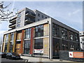
"Factory Quarter" new apartments, Larden Road W3
Formerly the CAV factory, this large site between Larden Road and Warple Way is being turned into the "Factory Quarter" to be mainly apartments with some commercial use.
CA Vandervell came to Acton before the first World War. In 1926 CAV was bought by Joseph Lucas, becoming CAV-Bosch in the 30's before reverting to CAV in 1939. In the 70's, the firm became Lucas CAV and, eventually, Prestolite after Lucas Industries was split up. CAV was the world leader in diesel technology.
Information from neighbour Net website http://nnet-server.com/
and Competition Commission website http://www.competition-commission.org.uk/rep_pub/reports/1960_1969/fulltext/025c02.pdf and "Made in Birmingham" website about Lucas, http://madeinbirmingham.org/lucas.htm .
Image: © David Hawgood
Taken: 25 Mar 2008
0.09 miles