IMAGES TAKEN NEAR TO
Hartswood Road, LONDON, W12 9NQ
Introduction
This page details the photographs taken nearby to Hartswood Road, W12 9NQ by members of the Geograph project.
The Geograph project started in 2005 with the aim of publishing, organising and preserving representative images for every square kilometre of Great Britain, Ireland and the Isle of Man.

There are currently over 7.5m images from over14,400 individuals and you can help contribute to the project by visiting https://www.geograph.org.uk
Image Map
Images are licensed for reuse under creativecommons.org/licenses/by-sa/2.0
Notes
- Clicking on the map will re-center to the selected point.
- The higher the marker number, the further away the image location is from the centre of the postcode.
Image Listing (67 Images Found)
Images are licensed for reuse under creativecommons.org/licenses/by-sa/2.0
Image
Details
Distance
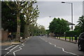
1

Hartswood Road, Stamford Brook
Looking to the right up the road shown in Image
Image: © Derek Harper
Taken: 21 Mar 2013
0.02 miles

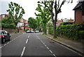

7
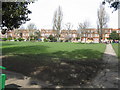
Across the park to Stamford Brook Road
Image: © Peter Whatley
Taken: 6 Apr 2010
0.06 miles
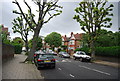
8
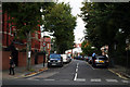
Stamford Brook: Flanchford Road
Looking north from its junction with Stamford Brook Road.
Image: © Dr Neil Clifton
Taken: 2 Oct 2012
0.06 miles
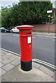
9
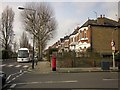
Hartswood Road, Stamford Brook
The junction with Stamford Brook Road, the B409. Across on the left is Stamford Brook Common, a small patch of access land.
Image: © Derek Harper
Taken: 21 Mar 2013
0.06 miles