IMAGES TAKEN NEAR TO
Laurence Mews, LONDON, W12 9AT
Introduction
This page details the photographs taken nearby to Laurence Mews, W12 9AT by members of the Geograph project.
The Geograph project started in 2005 with the aim of publishing, organising and preserving representative images for every square kilometre of Great Britain, Ireland and the Isle of Man.

There are currently over 7.5m images from over14,400 individuals and you can help contribute to the project by visiting https://www.geograph.org.uk
Image Map
Images are licensed for reuse under creativecommons.org/licenses/by-sa/2.0
Notes
- Clicking on the map will re-center to the selected point.
- The higher the marker number, the further away the image location is from the centre of the postcode.
Image Listing (75 Images Found)
Images are licensed for reuse under creativecommons.org/licenses/by-sa/2.0
Image
Details
Distance
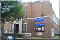
2
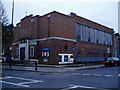
The Askew Road Church
Methodist and United Reformed at junction of Bassein Park Road and Askew Road, London W12.
Image: © Peter Holmes
Taken: 1 Dec 2008
0.04 miles
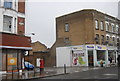
4
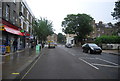
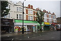
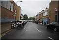
Shops in Askew Road
Shops in Askew Road, looking towards Uxbridge Road.
Image: © Phillip Perry
Taken: 29 Feb 2008
0.05 miles
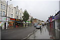
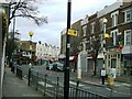
8
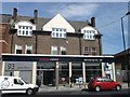
Tesco Express, North Hammersmith
No.93 Askew Road.
Image: © David Anstiss
Taken: 14 Apr 2013
0.06 miles