IMAGES TAKEN NEAR TO
Devonport Road, LONDON, W12 8NU
Introduction
This page details the photographs taken nearby to Devonport Road, W12 8NU by members of the Geograph project.
The Geograph project started in 2005 with the aim of publishing, organising and preserving representative images for every square kilometre of Great Britain, Ireland and the Isle of Man.

There are currently over 7.5m images from over14,400 individuals and you can help contribute to the project by visiting https://www.geograph.org.uk
Image Map
Images are licensed for reuse under creativecommons.org/licenses/by-sa/2.0
Notes
- Clicking on the map will re-center to the selected point.
- The higher the marker number, the further away the image location is from the centre of the postcode.
Image Listing (227 Images Found)
Images are licensed for reuse under creativecommons.org/licenses/by-sa/2.0
Image
Details
Distance
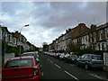
2
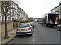
Houses on Warbeck Road, Shepherd's Bush, London, W12
Image: © JThomas
Taken: 13 Apr 2019
0.02 miles
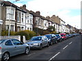
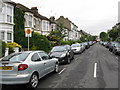
4
Warbeck Road, Shepherd's Bush, London, W12
Looking south.
Image: © JThomas
Taken: 13 Apr 2019
0.03 miles
7
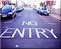
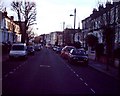
Thornfield Road, W12
Thornfield Road is littered with several fire paths, barriers and this marking in the road.
Image: © Phillip Perry
Taken: 8 Feb 2008
0.05 miles
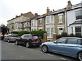
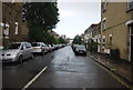
8
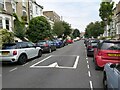
St. Stephen's Avenue, W12
St. Stephen's Avenue, W12 looking towards Goldhawk Road.
Image: © Phillip Perry
Taken: 8 Feb 2008
0.06 miles
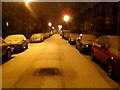
9
Street View in Shepherd's Bush
A view of St Stephen's Avenue looking towards the A4020 Uxbridge Road in the Shepherd's Bush area of London.
Image: © John P Reeves
Taken: 13 Jul 2021
0.06 miles