IMAGES TAKEN NEAR TO
Uxbridge Road, LONDON, W12 8ND
Introduction
This page details the photographs taken nearby to Uxbridge Road, W12 8ND by members of the Geograph project.
The Geograph project started in 2005 with the aim of publishing, organising and preserving representative images for every square kilometre of Great Britain, Ireland and the Isle of Man.

There are currently over 7.5m images from over14,400 individuals and you can help contribute to the project by visiting https://www.geograph.org.uk
Image Map
Images are licensed for reuse under creativecommons.org/licenses/by-sa/2.0
Notes
- Clicking on the map will re-center to the selected point.
- The higher the marker number, the further away the image location is from the centre of the postcode.
Image Listing (421 Images Found)
Images are licensed for reuse under creativecommons.org/licenses/by-sa/2.0
Image
Details
Distance
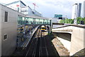
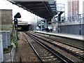
3
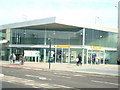
Shepherd's Bush London Overground station
Opened on 28 September 2008. It provides an interchange with the nearby Shepherd's Bush Central line tube station. There was a previous station on this site, Uxbridge Road, which closed in 1940.
Image: © Oxyman
Taken: 4 Feb 2009
0.01 miles
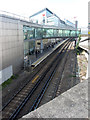
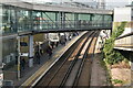
6
Shepherds Bush Station, London Overground 2009
View SE, under A402/A3220 Holland Park Roundabout, towards Kensington Olympia and Clapham Junction: West London Line. (See Image] for more detail).
Image: © Ben Brooksbank
Taken: 27 Aug 2009
0.01 miles
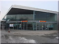
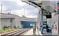
7
Shepherds Bush Station, London Overground 2009
View NW, towards Willesden Junction: new station on West London line, opened 28/9/08, in place of Uxbridge Road Station - closed after bombing in 10/40. (See also Image] etc.).
Image: © Ben Brooksbank
Taken: 27 Aug 2009
0.01 miles
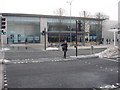
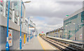
9

View into Shepherds Bush station, from the north-west side of the Shepherd's Bush roundabout
On the left, the Westfield shopping centre; on the right, the overhead signs mark the approach to the A40(M) Westway along a short dual carriageway that was formerly the tiny M41 and the only part of the long-planned West Cross Route that was actually constructed.
Image: © Christopher Hilton
Taken: 23 Feb 2015
0.01 miles