IMAGES TAKEN NEAR TO
Richmond Way, LONDON, W12 8LN
Introduction
This page details the photographs taken nearby to Richmond Way, W12 8LN by members of the Geograph project.
The Geograph project started in 2005 with the aim of publishing, organising and preserving representative images for every square kilometre of Great Britain, Ireland and the Isle of Man.

There are currently over 7.5m images from over14,400 individuals and you can help contribute to the project by visiting https://www.geograph.org.uk
Image Map
Images are licensed for reuse under creativecommons.org/licenses/by-sa/2.0
Notes
- Clicking on the map will re-center to the selected point.
- The higher the marker number, the further away the image location is from the centre of the postcode.
Image Listing (369 Images Found)
Images are licensed for reuse under creativecommons.org/licenses/by-sa/2.0
Image
Details
Distance
1
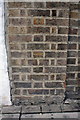
Benchmark on wall pier of Richmond Way
Ordnance Survey cut mark benchmark described on the Bench Mark Database at http://www.bench-marks.org.uk/bm41932
Image: © Roger Templeman
Taken: 10 Mar 2012
0.04 miles
2
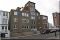
'Shepherd's East', Richmond Way
There is an OS benchmark Image on the wall pier next to the white post on the left side of the photo.
Image: © Roger Templeman
Taken: 10 Mar 2012
0.04 miles
3
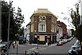
Shepherd's Bush: The 'Duke of Edinburgh' (closed)
Taken from the roundabout at the north end of Holland Road, with which, however, there is no direct road connection owing to the difference in levels.
The two roads visible here are Woodstock Grove to the left, and Richmond Way to the right.
Image: © Dr Neil Clifton
Taken: 2 Oct 2012
0.05 miles
5
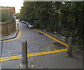
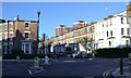
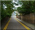
Hansard Mews
A quiet back street with setted surface, parallel to Holland Road.
Image: © Stephen Craven
Taken: 16 Aug 2014
0.06 miles
6
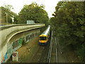
London Overground train leaving Shepherds Bush
The train has just emerged from the tunnel under the roundabout. For a view back from the next bridge, see Image
Image: © Stephen Craven
Taken: 16 Aug 2014
0.06 miles
7
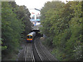
London Overground train approaching Shepherds Bush
A view from the road bridge on Addison Gardens. See Image for a view in the other direction.
Image: © Stephen Craven
Taken: 16 Aug 2014
0.07 miles
8
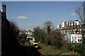
Overground at Shepherd's Bush
Seen approaching the station at Olympia, which lies about a third of a mile beyond the bridge.
Image: © Peter Trimming
Taken: 15 Mar 2017
0.07 miles
9
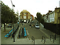
Woodstock Grove docking station
A double row of hire bikes across the road from Shepherds Bush tube station.
Image: © Stephen Craven
Taken: 16 Aug 2014
0.07 miles
10
Orange Way after Wiltshire (634)
Here's a look into Hansard Mews from Lower Addison Gardens.
Image: © Shazz
Taken: 23 Sep 2013
0.07 miles