IMAGES TAKEN NEAR TO
St. Stephens Avenue, LONDON, W12 8JH
Introduction
This page details the photographs taken nearby to St. Stephens Avenue, W12 8JH by members of the Geograph project.
The Geograph project started in 2005 with the aim of publishing, organising and preserving representative images for every square kilometre of Great Britain, Ireland and the Isle of Man.

There are currently over 7.5m images from over14,400 individuals and you can help contribute to the project by visiting https://www.geograph.org.uk
Image Map
Images are licensed for reuse under creativecommons.org/licenses/by-sa/2.0
Notes
- Clicking on the map will re-center to the selected point.
- The higher the marker number, the further away the image location is from the centre of the postcode.
Image Listing (169 Images Found)
Images are licensed for reuse under creativecommons.org/licenses/by-sa/2.0
Image
Details
Distance
1

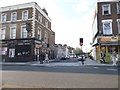
Stowe Road, W12
Looking from the junction of Scott's Road, Stowe Road
Image: © Phillip Perry
Taken: 8 Feb 2008
0.02 miles
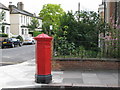
2
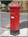
Penfold postbox, Godolphin Road / Thornfield Road, W12
Image: © Mike Quinn
Taken: 25 Jun 2008
0.05 miles
3
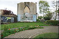
Turf zone GoodDolphin
Park on Good Dolphin Park, Godolphin Road, Shepherd's Bush, London.
Image: © Ian S
Taken: 23 Apr 2023
0.06 miles
5
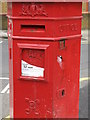
Penfold postbox, Godolphin Road, W12 - royal cipher and crest
Image: © Mike Quinn
Taken: 25 Jun 2008
0.08 miles
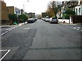
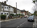
6
Thornfield Road, W12
Shows the location of Image
Image: © Mike Quinn
Taken: 25 Jun 2008
0.08 miles
9
Devonport Road at the junction of Goldhawk Road
Image: © David Howard
Taken: 12 Apr 2014
0.09 miles