IMAGES TAKEN NEAR TO
Gaumont Terrace, Lime Grove, LONDON, W12 8HR
Introduction
This page details the photographs taken nearby to Gaumont Terrace, Lime Grove, W12 8HR by members of the Geograph project.
The Geograph project started in 2005 with the aim of publishing, organising and preserving representative images for every square kilometre of Great Britain, Ireland and the Isle of Man.

There are currently over 7.5m images from over14,400 individuals and you can help contribute to the project by visiting https://www.geograph.org.uk
Image Map
Images are licensed for reuse under creativecommons.org/licenses/by-sa/2.0
Notes
- Clicking on the map will re-center to the selected point.
- The higher the marker number, the further away the image location is from the centre of the postcode.
Image Listing (291 Images Found)
Images are licensed for reuse under creativecommons.org/licenses/by-sa/2.0
Image
Details
Distance
1
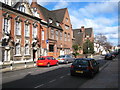
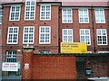
Lime Grove Shepherd's Bush
The building on the left is the Hammersmith Public Baths & Washhouse building, scene of boxing matches and was familiar to viewers of 1960s Saturday afternoon TV wrestling programmes as Lime Grove Baths. It was also the location for the baths scene in the 1979 film 'Quadrophenia'. The building next to it is now part of the London College of Fashion but was constructed in 1904 as the Hammersmith College of Art & Building.
Image: © Rod Allday
Taken: 6 Mar 2010
0.03 miles
2
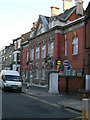
Hammersmith Public Baths, Lime Grove, London W12
Image: © Robin Sones
Taken: 13 Jul 2006
0.03 miles
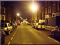
4
Council Tow Truck
A sign of the times, a council tow truck placing an illegally parked car on the back waiting to take it to the car pound.
Image: © Phillip Perry
Taken: 8 Feb 2008
0.06 miles
5
Miles Coverdale primary school
Miles Coverdale primary school in Coverdale Road, W12
Image: © Phillip Perry
Taken: 29 Feb 2008
0.08 miles
6
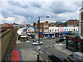
Shepherds Bush Market
The Goldhawk Road entrance.
Image: © Des Blenkinsopp
Taken: 30 Jul 2015
0.08 miles
7

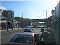
Titmuss Street W12
From the junction with Goldhawk Road W12
Image: © Robin Sones
Taken: 19 Mar 2010
0.09 miles
8
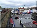
Goldhawk Road rail bridge, Goldhawk Road W12
Looking toward the junction with Wells Road W12
Image: © Robin Sones
Taken: 19 May 2009
0.09 miles
9
Shepherd's Bush Market
Viewed from the southbound platform of Goldhawk Road Underground station, this view looks across Goldhawk Road to the southern entrance of Shepherd's Bush Market. The market dates from the early 20th century. It runs parallel to the elevated railway as far as Uxbridge Road where the actual Shepherd's Bush Market station is to be found.
Image: © Marathon
Taken: 15 Jun 2011
0.09 miles
10
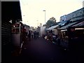
Shepherd's Bush Market, W12
A few stall still open although it's gone 6pm.
Image: © Phillip Perry
Taken: 6 Oct 2010
0.10 miles