IMAGES TAKEN NEAR TO
Lime Grove, LONDON, W12 8EA
Introduction
This page details the photographs taken nearby to Lime Grove, W12 8EA by members of the Geograph project.
The Geograph project started in 2005 with the aim of publishing, organising and preserving representative images for every square kilometre of Great Britain, Ireland and the Isle of Man.

There are currently over 7.5m images from over14,400 individuals and you can help contribute to the project by visiting https://www.geograph.org.uk
Image Map
Images are licensed for reuse under creativecommons.org/licenses/by-sa/2.0
Notes
- Clicking on the map will re-center to the selected point.
- The higher the marker number, the further away the image location is from the centre of the postcode.
Image Listing (308 Images Found)
Images are licensed for reuse under creativecommons.org/licenses/by-sa/2.0
Image
Details
Distance
1
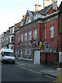
Hammersmith Public Baths, Lime Grove, London W12
Image: © Robin Sones
Taken: 13 Jul 2006
0.02 miles
2
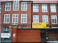
Miles Coverdale primary school
Miles Coverdale primary school in Coverdale Road, W12
Image: © Phillip Perry
Taken: 29 Feb 2008
0.03 miles
3
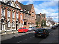
Lime Grove Shepherd's Bush
The building on the left is the Hammersmith Public Baths & Washhouse building, scene of boxing matches and was familiar to viewers of 1960s Saturday afternoon TV wrestling programmes as Lime Grove Baths. It was also the location for the baths scene in the 1979 film 'Quadrophenia'. The building next to it is now part of the London College of Fashion but was constructed in 1904 as the Hammersmith College of Art & Building.
Image: © Rod Allday
Taken: 6 Mar 2010
0.06 miles
5
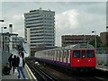
Shepherd's Bush Underground Station
Shepherd's Bush Underground Station on the Hammersmith & City Line looking northwards. Almost all of the buildings in the background form part of the BBC's Television Centre. The tall one in the middle is known as East Tower and several large satellite dishes can be seen, which form part of the BBC's satellite uplink/downlink system.
Image: © Hywel Williams
Taken: 11 Jun 2003
0.09 miles
7
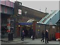
Shepherd's Bush Market Underground Station, Uxbridge Road W12
Image: © Robin Sones
Taken: 1 May 2012
0.09 miles
8
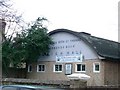
St. Stephen with St. Thomas Parish Hall
Probably unusual for an urban area, this parish hall looks as if it's been converted from an old Anderson shelter. This building is in the extreme south-west corner of this square.
Image: © Phillip Perry
Taken: 29 Feb 2008
0.09 miles
9
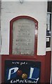
Old Milestone by the A4020, Uxbridge Road, Shepherd's Bush
Carved stone post by the A4020 (was A40), in parish of HAMMERSMITH (HAMMERSMITH AND FULHAM District), Shepherd's Bush; Uxbridge Road, West of junction with Lime Grove, W12, in wall to left of White Horse PH entrance, on South side of road. Old Uxbridge stone, erected by the Tyburn to Uxbridge turnpike trust in the 18th century.
Boarded over after 2019.
Inscription reads:-
HAMMERSMITH
-----
PARISH
-----
LONDON
III MILES
-----
UXBRIDGE
XII MILES
-----
Milestone Society National ID: MX_LW03.
Image: © C Woodward
Taken: 23 Mar 2005
0.10 miles
10
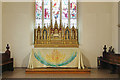
St Stephen & St Thomas, Uxbridge Road - Sanctuary
Image: © John Salmon
Taken: 29 Sep 2014
0.10 miles