IMAGES TAKEN NEAR TO
Wood Lane, LONDON, W12 7RP
Introduction
This page details the photographs taken nearby to Wood Lane, W12 7RP by members of the Geograph project.
The Geograph project started in 2005 with the aim of publishing, organising and preserving representative images for every square kilometre of Great Britain, Ireland and the Isle of Man.

There are currently over 7.5m images from over14,400 individuals and you can help contribute to the project by visiting https://www.geograph.org.uk
Image Map
Images are licensed for reuse under creativecommons.org/licenses/by-sa/2.0
Notes
- Clicking on the map will re-center to the selected point.
- The higher the marker number, the further away the image location is from the centre of the postcode.
Image Listing (158 Images Found)
Images are licensed for reuse under creativecommons.org/licenses/by-sa/2.0
Image
Details
Distance
1
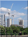
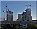
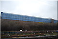
View to tower blocks under construction
From South Africa Road.
Image: © Oast House Archive
Taken: 16 Jun 2015
0.04 miles
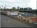
2
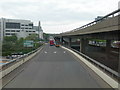
The Wood Lane Offslip from the A40 Westway
Heading to Wood Lane on the offslip from the A40 Westway. Turn left for Shepherds Bush, turn right for Harlesden, and ahead to rejoin A40 for Acton.
This is not an easy feature to photograph as there are no overbridges anywhere along here that a pedestrian can use, and pedestrians and cycles are not permitted on the road itself. This photo was done from the top deck of a number 220 bus which was on diversion from its normal route along Wood Lane.
Image: © Danny P Robinson
Taken: 6 May 2007
0.05 miles
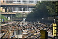
6
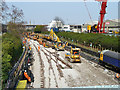
Track replacement, White City
The Central Line has been closed west of Marble Arch for the weekend, and this lot has to be in working order for Monday morning. This is lunchtime Sunday.
Image: © Robin Webster
Taken: 27 Mar 2011
0.08 miles
7
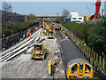
Track replacement, White City
The Central Line has been closed west of Marble Arch for the weekend, and this lot has to be in working order for Monday morning. This is lunchtime Sunday. The far train is seen 20 minutes later in Image
Image: © Robin Webster
Taken: 27 Mar 2011
0.08 miles
8
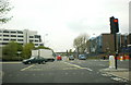
Wood Lane, north of Shepherd's Bush
Image: © Alexander P Kapp
Taken: 14 Apr 2009
0.09 miles
9
A3220 and a Mobile Home Site Below
Just after the Northern Roundabout and heading south.
This combination of features is not easy to photograph as there are no overbridges anywhere along here that a pedestrian can use, and pedestrians and cycles are not permitted on the road itself. This photo was done from the top deck of a number 220 bus which was on diversion from its normal route along Wood Lane. (The slight yellow tinge at the bottom of the picture is a reflection from the yellow handrail on the front window)
Image: © Danny P Robinson
Taken: 6 May 2007
0.09 miles
10
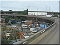
Approaching the Northern Roundabout on the A3220
Showing the A40 Westway Flyover on the horizon and a scrapyard below.
This combination of features is not easy to photograph as there are no overbridges anywhere along here that a pedestrian can use, and pedestrians and cycles are not permitted on the road itself. This photo was done from the top deck of a number 220 bus which was on diversion from its normal route along Wood Lane. (The slight yellow tinge at the bottom of the picture is a reflection from the yellow handrail on the front window)
Image: © Danny P Robinson
Taken: 6 May 2007
0.09 miles