IMAGES TAKEN NEAR TO
Batman Close, White City Estate, LONDON, W12 7NU
Introduction
This page details the photographs taken nearby to Batman Close, White City Estate, W12 7NU by members of the Geograph project.
The Geograph project started in 2005 with the aim of publishing, organising and preserving representative images for every square kilometre of Great Britain, Ireland and the Isle of Man.

There are currently over 7.5m images from over14,400 individuals and you can help contribute to the project by visiting https://www.geograph.org.uk
Image Map
Images are licensed for reuse under creativecommons.org/licenses/by-sa/2.0
Notes
- Clicking on the map will re-center to the selected point.
- The higher the marker number, the further away the image location is from the centre of the postcode.
Image Listing (236 Images Found)
Images are licensed for reuse under creativecommons.org/licenses/by-sa/2.0
Image
Details
Distance
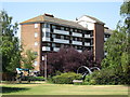
2
Batman Close / Hammersmith Park, W12
Batman Close (yes that's right) part of the White City estate taken from inside Hammersmith Park.
Image: © Phillip Perry
Taken: 19 Apr 2007
0.02 miles
3
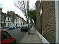
Tunis Road, W12 (1)
Tunis Road - This picture is right on the boundary of this square, the long white lines down the middle of the road represents the border to the next square (TQ 2281).
Image: © Phillip Perry
Taken: 7 Feb 2008
0.02 miles
4
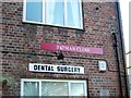
Dental Surgery - 1 Batman Close
The Batman Close dental surgery.
Image: © Phillip Perry
Taken: 30 Jan 2008
0.03 miles
5
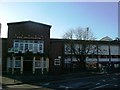
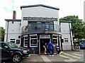
The Springbok, White City Estate
The Springbok, in South Africa Road, White City Estate and a row of shops to the right. Above them the flats of Batman Close.
Image: © Phillip Perry
Taken: 30 Jan 2008
0.03 miles
6
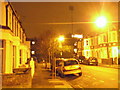
Stanlake Road, W12
Trying out my new camera more than anything else on ISO 1600 setting.
The row of houses facing are the back of the properties in Loftus Road, and one of the floodlight pylons from the QPR football ground.
Image: © Phillip Perry
Taken: 15 Dec 2009
0.04 miles
7
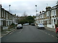
Stanlake Road, W12
Standing on the square boundary to square TQ2279, stanlake Road on the corner of Tunis Road, W12. The floodlights that can be seen are at the home end of Queen's Park Rangers FC.
Image: © Phillip Perry
Taken: 7 Feb 2008
0.04 miles
8
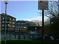
Batman Close, W12
Looking towards Hammersmith Park, the round building in the distance is the BBC television centre.
Image: © Phillip Perry
Taken: 30 Jan 2008
0.04 miles
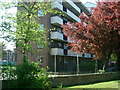
9
The Queens Tavern on South Africa Road
The Queens Tavern was formerly named the Springbok.
Image: © Steve Daniels
Taken: 24 Aug 2021
0.05 miles
10
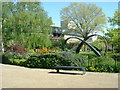
Hammersmith Park, W12
Hammersmith Park that's not in Hammersmith, (like Hammersmith Hospital isn't in Hammersmith either) with an art installation. The buildings at the back are part of the BBC television centre.
Image: © Phillip Perry
Taken: 19 Apr 2007
0.05 miles