IMAGES TAKEN NEAR TO
Ariel Way, LONDON, W12 7NS
Introduction
This page details the photographs taken nearby to Ariel Way, W12 7NS by members of the Geograph project.
The Geograph project started in 2005 with the aim of publishing, organising and preserving representative images for every square kilometre of Great Britain, Ireland and the Isle of Man.

There are currently over 7.5m images from over14,400 individuals and you can help contribute to the project by visiting https://www.geograph.org.uk
Image Map
Images are licensed for reuse under creativecommons.org/licenses/by-sa/2.0
Notes
- Clicking on the map will re-center to the selected point.
- The higher the marker number, the further away the image location is from the centre of the postcode.
Image Listing (349 Images Found)
Images are licensed for reuse under creativecommons.org/licenses/by-sa/2.0
Image
Details
Distance
1
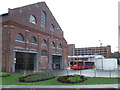
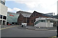
White City bus station
The building in the foreground, dating from around 1898, was built as an electricity generating station for the Central Line. It was later used as a machine tool shop before falling into disuse.
The building is Grade II listed, and has been brought back into use as a covered parking area for buses serving the new White City bus station. The bus station opened in 2008 to serve the adjacent Westfield shopping centre.
In the photo is a "bendy bus" on route 207. Bendy buses are being withdrawn from London. Route 207 is due to revert to standard double-deck buses by the end of 2011.
Image: © Malc McDonald
Taken: 22 Jan 2011
0.00 miles
2
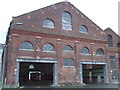
White City bus station
This building, dating from around 1898, was originally a power generating station for the underground railway (now London Underground's Central Line). It was later used as a machine tool shop before falling derelict. With the opening of the new Westfield shopping centre, the building has been brought back into use as a parking area for buses terminating at the new White City bus station.
The building is Grade II listed.
Image: © Malc McDonald
Taken: 22 Jan 2011
0.00 miles
3
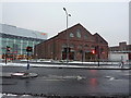
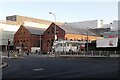
Former railway goods depot
For the reason of their beauty? and other things, this building has gained a Grade 2 listed building status. It is now being used as a bus depot.
Image: © Alexander P Kapp
Taken: 21 Dec 2010
0.01 miles
4

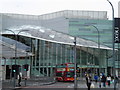
Bus Station
By White City and Wood Lane underground stations, on the northern edge of the Westfield Shopping Centre at Shepherd's Bush.
Image: © Colin Smith
Taken: 12 Jun 2012
0.01 miles
5
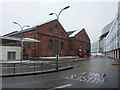
Former railway goods depot
For the reason of their beauty? and other things, this building has gained a Grade 2 listed building status. It is now being used as a bus depot.
Image: © Alexander P Kapp
Taken: 21 Dec 2010
0.01 miles
7
Entrance to Westfield Shopping Centre W12
Image: © Robin Sones
Taken: 19 Mar 2010
0.02 miles
8
Westfield Bus Station
Westfield Shopping Centre Bus Station is dwarfed by the listed ex-Central London Railway generating station buildings, now the only old buildings in the area. The original White City Station was beneath the forecourt, only a ventilation shaft remaining behind the poster board on the right.
Image: © Bob Walters
Taken: 8 Feb 2023
0.02 miles
9
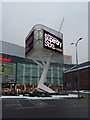
Advertising sculpture, Westfield Shopping Centre
The advert seemed to change every 30secs or so
Image: © Alexander P Kapp
Taken: 21 Dec 2010
0.02 miles
10

Westfield
Bike and bus stance outside the large Westfield Shopping Centre at Shepherd's Bush. Overground and underground railway stations are also within a few yards of this spot.
http://www.tfl.gov.uk/corporate/modesoftransport/1574.aspx
Image: © Colin Smith
Taken: 12 Jun 2012
0.03 miles