IMAGES TAKEN NEAR TO
Fountain Park Way, LONDON, W12 7LG
Introduction
This page details the photographs taken nearby to Fountain Park Way, W12 7LG by members of the Geograph project.
The Geograph project started in 2005 with the aim of publishing, organising and preserving representative images for every square kilometre of Great Britain, Ireland and the Isle of Man.

There are currently over 7.5m images from over14,400 individuals and you can help contribute to the project by visiting https://www.geograph.org.uk
Image Map
Images are licensed for reuse under creativecommons.org/licenses/by-sa/2.0
Notes
- Clicking on the map will re-center to the selected point.
- The higher the marker number, the further away the image location is from the centre of the postcode.
Image Listing (262 Images Found)
Images are licensed for reuse under creativecommons.org/licenses/by-sa/2.0
Image
Details
Distance
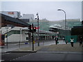
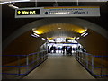
1
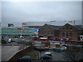
Car Park and Westfield Shopping Centre
Taken from Wood Lane Underground Station
Image: © Robin Sones
Taken: 19 Mar 2010
0.03 miles
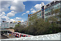
2
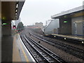
Wood Lane station
The present-day Hammersmith and City line was opened on 13th June 1864 by the Metropolitan Railway as the Hammersmith branch line. The railway became part of London Underground in 1922.
n 1908 the Franco-British Exhibition and the 1908 Summer Olympics came to London. The Metropolitan Railway opened its Wood Lane station on the Hammersmith branch to serve the event area. The station opened and closed intermittently, and was renamed twice, as Wood Lane (White City) in 1920 and White City in 1947, before it finally closed in 1959 following fire damage.
When work commenced on the Westfield Shopping Centre in 2005 it was decided to rebuild Shepherd's Bush Central line station, construct a new Shepherd's Bush station on the West London Line, and provide two new bus interchanges to serve the planned shopping complex. It was also decided to build a new station on the Hammersmith & City line, on a site just south-west of the old Metropolitan station on Wood Lane. It was named Wood Lane and was the first time that a brand new station on the Tube had been given the name of a disused station. The station opened on 12 October 2008.
This view looks towards Latimer Road station.
Image: © Marathon
Taken: 6 Nov 2013
0.04 miles
3
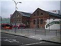
Bus sheds, Wood Lane W12
At the junction with Ariel Way W12
Image: © Robin Sones
Taken: 19 Mar 2010
0.05 miles
4
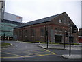
Bus station, Westfield Shopping Centre W12
Image: © Robin Sones
Taken: 19 Mar 2010
0.05 miles
5
56 Wood Lane
What looks like four rather tired green-hued 1960s office blocks, overlooking White City tube station. An Imperial College sign states, "ThinkSpace / The home of today's innovators".
Image: © Stephen Richards
Taken: 30 Apr 2016
0.05 miles
6
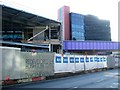
Wood Lane station (01-08)
Corner of Wood Lane and Ariel Way, the new Hammersmith & City line station Wood Lane under construction, to coincide with opening of the whitecity Shopping centre on October 30 2008, said to be the first station to open on an existing line for over 70 years. The glass fronted building is Network House.
whitecity has now been renamed Westfield for the opening, see also Image
**note to mods** ''whitecity'' is written as is and not White City, WhiteCity or Whitecity, thx. ***
Image: © Phillip Perry
Taken: 30 Jan 2008
0.05 miles
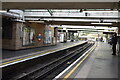
9
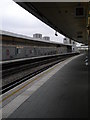
Platform, Wood Lane Underground Station
Image: © Robin Sones
Taken: 19 Mar 2010
0.06 miles