IMAGES TAKEN NEAR TO
Poplar Mews, Uxbridge Road, LONDON, W12 7JS
Introduction
This page details the photographs taken nearby to Poplar Mews, Uxbridge Road, W12 7JS by members of the Geograph project.
The Geograph project started in 2005 with the aim of publishing, organising and preserving representative images for every square kilometre of Great Britain, Ireland and the Isle of Man.

There are currently over 7.5m images from over14,400 individuals and you can help contribute to the project by visiting https://www.geograph.org.uk
Image Map
Images are licensed for reuse under creativecommons.org/licenses/by-sa/2.0
Notes
- Clicking on the map will re-center to the selected point.
- The higher the marker number, the further away the image location is from the centre of the postcode.
Image Listing (364 Images Found)
Images are licensed for reuse under creativecommons.org/licenses/by-sa/2.0
Image
Details
Distance
1
Shepherd's Bush-Macfarlane Road
Knickerbocker Glory.
Image: © Ian Rob
Taken: 3 Feb 2018
0.01 miles
2
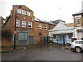
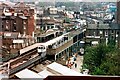
Uxbridge Road, W12
An underground train approaching Shepherd's Bush station. On the left is Shepherd's Bush library until a new branch opens inside the Westfield whitecity shopping centre in 2009.
Image: © Phillip Perry
Taken: 30 Jan 2008
0.01 miles
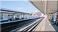
4
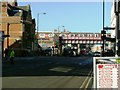
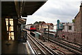
Shepherd's Bush Station - Looking South
This is the Hammersmith & City line, with the bridge over Uxbridge Road following the end of the platforms. The arched entrance to Shepherd's Bush market is just visible to the left of the bridge.
Image: © Peter Whatley
Taken: 27 May 2009
0.01 miles
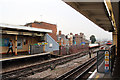
6
Shepherd's Bush Market station l
Renamed Shepherd's Bush Market from Shepherd's Bush when Wood Lane (the next station along) opened in early October 2008 meant that all the signs and tube maps had to be changed.
Image: © Phillip Perry
Taken: 28 Oct 2008
0.02 miles
7
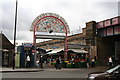
Shepherds Bush Market
The market is just across the road from the Hammersmith & City line station.
Image: © Dr Neil Clifton
Taken: 20 Sep 2007
0.02 miles
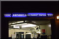
8
Shepherds Bush Market Station, London Underground
View northward, towards Paddington, Edgware Road, Farringdon, Whitechapel and Barking: Hammersmith & City Line, formerly Metropolitan & GWR Joint. 'Market' recently (10/08) added to the name, for the new Westfield Centre.
Image: © Ben Brooksbank
Taken: 8 Sep 2009
0.02 miles
9
Shepherds Bush Station
A view of Shepherds Bush Hammersmith & City Line Station with an eastbound train at the platform. In the distance can be seen Goldhawk Road Station. This shot is from the roof of the East Tower block at BBC Television Centre, a position not possible today as the tower has been demolished.
Image: © Bob Walters
Taken: 20 Apr 1988
0.02 miles
10
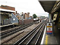
Shepherds Bush station, Hammersmith & City Line
A northbound train approaches the platforms at this elevated station.
Image: © Dr Neil Clifton
Taken: 20 Sep 2007
0.03 miles