IMAGES TAKEN NEAR TO
Frithville Gardens, LONDON, W12 7JL
Introduction
This page details the photographs taken nearby to Frithville Gardens, W12 7JL by members of the Geograph project.
The Geograph project started in 2005 with the aim of publishing, organising and preserving representative images for every square kilometre of Great Britain, Ireland and the Isle of Man.

There are currently over 7.5m images from over14,400 individuals and you can help contribute to the project by visiting https://www.geograph.org.uk
Image Map
Images are licensed for reuse under creativecommons.org/licenses/by-sa/2.0
Notes
- Clicking on the map will re-center to the selected point.
- The higher the marker number, the further away the image location is from the centre of the postcode.
Image Listing (388 Images Found)
Images are licensed for reuse under creativecommons.org/licenses/by-sa/2.0
Image
Details
Distance
1
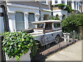
Land Rover at Frithville Gardens
Image: © Oast House Archive
Taken: 16 Jun 2015
0.02 miles
2
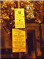
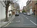
Oh, my head hurts
Talk about too much info...........
What I didn't show, was a 3rd sign notifying about future parking space closures, Hammersmith & Fulham council need taller streetlights to display all the wretched signs. Yes, they're charging for the 2 'Boxing Days' and New Years Day.
Image: © Phillip Perry
Taken: 15 Dec 2009
0.03 miles
4
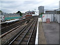
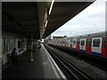
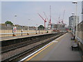
View from Shepherd's Bush Market station
The line here was opened in 1864. However, the station now known as Shepherd's Bush Market, but then as Shepherd's Bush, was only moved in 1914 from its original location between Uxbridge Road and Goldhawk Road to this location on the north side of Uxbridge Road. Trains on the Hammersmith & City Line serve the station and now also, in an effort to improve its reliability, the Circle Line. The battery of satellite dishes in the distance belong to the BBC Television Centre.
Image: © Marathon
Taken: 15 Jun 2011
0.05 miles
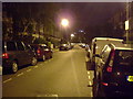
5
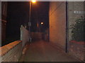
Unnamed footpath, W12
Between Frithville Gardens & Stanlake Road, W12.
Image: © Phillip Perry
Taken: 13 Jun 2008
0.06 miles
6
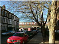
Macfarlane Road, W12
Where the railway line cuts a corner of the road, and the arches are filled with the usual car repair firms.
Image: © Phillip Perry
Taken: 30 Jan 2008
0.06 miles
7
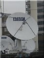
BBC Satellite dishes
Taken from Shepherd's Bush Market Underground Station.
Image: © Robin Sones
Taken: 20 Oct 2009
0.07 miles
8
View along the Hammersmith and City and Circle line tracks towards Wood Lane station from Shepherd's Bush Market station
Looking north-northeast.
Image: © Robert Lamb
Taken: 9 Jun 2013
0.07 miles
9
Shepherds Bush Market Station platform
Image: © Oast House Archive
Taken: 18 Aug 2016
0.07 miles
10
Swindon Street, W12
Looking at Swindon Street in square TQ2380, across the road in the other part of Swindon Street in square TQ 2379. Taken in Tunis Road, the road is split in half with the boundary going straight through the length of Tunis Road.
Image: © Phillip Perry
Taken: 7 Feb 2008
0.08 miles